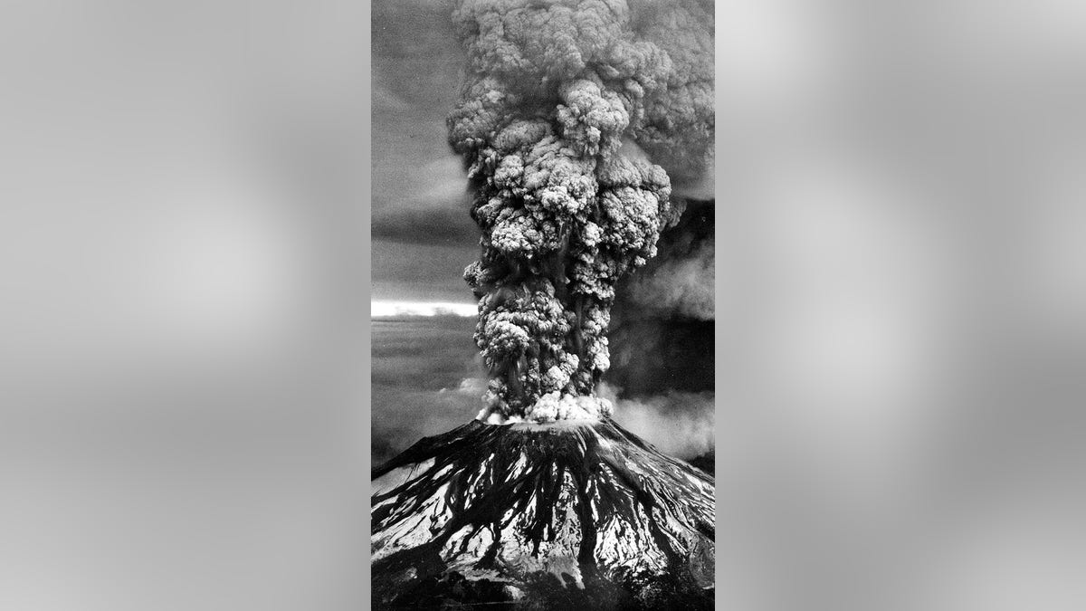
Washington's Mount St. Helens erupted for nine hours on this day in history, May 18, 1980, killing 57 people and causing the largest landslide in recorded history.
Before the eruption, Mount St. Helens had a height of 9,677 feet, according to the United States Geological Survey (USGS) website. It was the fifth tallest mountain in Washington state.
“However, it stood out magnificently from the surrounding hills because it rose thousands of feet above them and had a perennial covering of ice and snow,” the site said.
ON THIS DAY IN HISTORY, MAY 17, 1954, THE SUPREME COURT DEFEATS SEGREGATION IN LANDMARK BROWN V. BOARD OF EDUCATION
That changed on May 18, when the volcano erupted for the first time in more than a century, the USGS says.
Once the dust, literally and figuratively, settled after the eruption, it was discovered that Mount St. Helens had lost approximately 1,300 feet of its cone.
Mount St. Helens before the devastating eruption of May 18, 1980.
In its place was a horseshoe-shaped crater, according to the USGS.
The highest point of the crater, located on the southwest side of the mountain, is 8,365 feet, according to the website.
The eruption occurred almost exactly two months after seismic activity began on the long-dormant volcano, the USGS said.
On March 16, 1980, a “series of small earthquakes” began to shake the area. Eleven days later, on March 27, after hundreds of small earthquakes, Mount St. Helens had a relatively small eruption, the first since 1857.
ON THIS DAY IN HISTORY, MAY 15, 1800, PRESIDENT ADAMS MOVES THE FEDERAL GOVERNMENT FROM PHILADELPHIA TO DC
In that eruption, “steam explosions tore a 60 to 75 m (200 to 250 ft) wide crater through the volcano's summit ice sheet and covered the snow-covered southeastern sector with dark ash,” he said. the USGS.
These eruptions continued until April 22, the USGS said.
After an approximately two-week halt in volcanic activity, smaller eruptions and earthquakes continued from May 7 to 17.
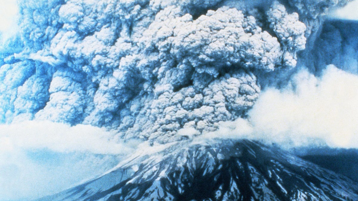
An iconic aerial view of the eruption of Mount St. Helens on May 18, 1980. Ash entered the atmosphere for nine hours. (Getty Images)
“At that time, more than 10,000 earthquakes had shaken the volcano and the northern flank had grown about 140 m (450 ft) to form a prominent bulge,” the USGS said.
This bulge was “strong evidence that molten rock (magma) had risen into the volcano” and was growing at a rate of up to five feet per day.
ON THIS DAY IN HISTORY, AUGUST 25, 1916, THE NATIONAL PARK SERVICE WAS CREATED UNDER PRESIDENT WILSON
At 8:32 a.m. on May 18, a magnitude 5.1 earthquake “with no immediate precursors” struck Mount Saint Helens, triggering “a rapid series of events,” the USGS said.
“At the same time as the earthquake, the northern bulge and summit of the volcano slid as a massive landslide – the largest debris avalanche on Earth in recorded history,” they said.
“A small eruption column, dark and rich in ash, rose directly from the base of the debris avalanche escarpment, and another from the summit crater rose to about 200 m (650 ft) high,” they said.
Mount St. Helens lost about 1,300 feet of elevation after the eruption. (Getty Images)
The volume of the avalanche is equivalent to one million Olympic-size swimming pools, the USGS added.
After the landslide, the destruction continued.
The landslide had removed part of the “cryptodome,” which was “a very hot, highly pressurized body of magma,” the USGS said.
With the cyptodome removed, Mount St. Helens' magmatic system depressurized, causing “powerful eruptions that exploded laterally through the sliding debris,” knocking 300 meters off the mountain's height.
AMERICA THE BEAUTIFUL: 50 ESSENTIAL PLACES THAT TELL OUR NATIONAL HISTORY
The cloud of tephra, or rock fragments, reached 15 miles in 15 minutes, the USGS said.
The consequences of the initial eruption were devastating.
“Virtually no trees remained from what was once dense forest” within the six-mile radius of the former summit, and other trees were downed and burned, the USGS said.
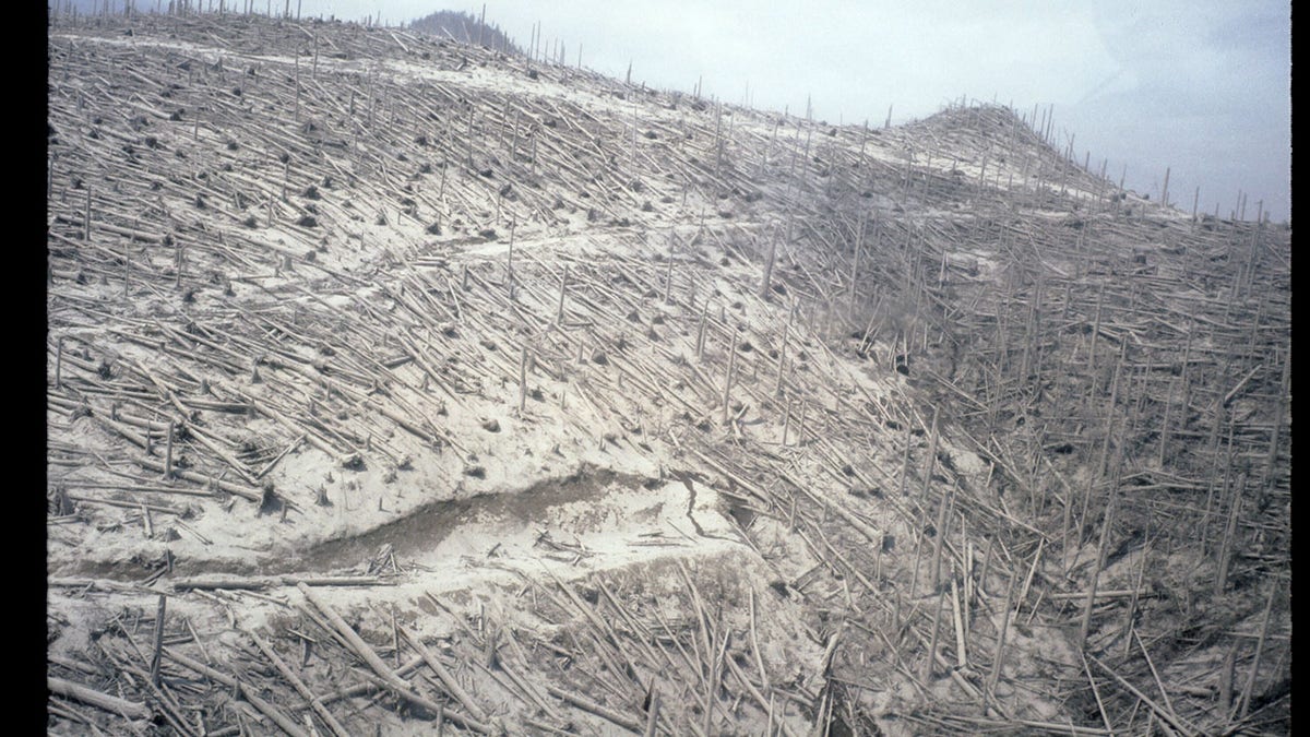
The dense ancient forest surrounding Mount St. Helens was devastated by the May 1980 landslide and eruption. (Getty Images)
“The devastated area of 600 km2 (230 mi2) was covered by a deposit of hot debris transported by the explosion,” the site said.
The eruption later became a “Plinian eruption,” defined as “one that produces a column of sustained convection of pyroclasts and gas rising >25 km above sea level,” the Science Direct website says.
ON THIS DAY IN HISTORY, MARCH 1, 1872, MAJESTIC YELLOWSTONE BECOMES AMERICA'S FIRST NATIONAL PARK
The Plinian eruption lasted nine hours and sent 520 million tons of ash into the air.
The ash was so thick that the city of Spokane, Washington, located 400 kilometers from Mount St. Helens, was plunged into total darkness, the USGS said.
More than four inches of ash covered Yakima, Washington, Getty reported at the time.

Rick Cole, director of Yakima Emergency Services, is shown shaking volcanic ash from his car. (Getty Images)
“Significant ash falls occurred as far away as central Montana, with ash falling visibly as far as the Great Plains of the central United States, more than 1,500 km (930 miles) away,” the USGS said.
“The ash cloud spread across the United States in three days and circled the Earth in 15 days.”
ON THIS DAY IN HISTORY, JAN. DECEMBER 28, 1986, THE SPACE SHUTTLE CHALLENGER EXPLODES, SHOCKING THE NATION
The explosion also triggered something called a “lahar,” which is an “Indonesian term that describes a cold or hot mixture of water and rock fragments that flows down the slopes of a volcano and typically enters a river valley,” the USGS said. .
In the case of Mount St. Helens, the snow-capped peak melted in the initial eruption.
That rush of water, combined with the flow of rocks, created a lahar.
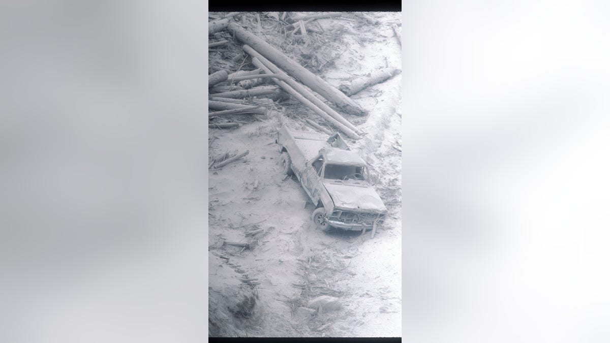
A pickup truck covered in ash and other debris after the eruption of Mount St. Helens. (Getty Images)
In the weeks leading up to May 18, people living near Mount St. Helens were evacuated, according to an article in American Scientist.
The area immediately surrounding Mount St. Helens was divided into a “red zone” and a “blue zone”.
Of the 57 people who died in the eruption, only one, Harry Randall Truman, did not have express permission to be near the mountain on the day of the eruption, and most of the deaths actually occurred outside the boundaries of the blue zone. said the American scientist. .
CLICK HERE TO SUBSCRIBE TO OUR LIFESTYLE NEWSLETTER
Truman, an 83-year-old man who had lived near Mount St. Helens for 54 years, refused to follow evacuation orders and leave the red zone.

Harry R. Truman, owner of the Spirit Lake Lodge and a long-time resident of nearby Mount Saint Helens, refused to evacuate. He died in the eruption. (Getty Images)
In a colorful interview with National Geographic before the eruption, Truman said, “I'm going to stay here because, I'll tell you why, my home and my (expletive) life are here.”
“My wife and I promised years and years ago that we would never leave Spirit Lake. We loved it. It's a part of me and I'm a part of that (expletive) mountain,” he said.
CLICK HERE TO GET THE FOX NEWS APP
Truman's remains were never found.
For more lifestyle articles, visit www.foxnews.com/lifestyle.