The latest round of atmospheric river storms drenched Southern California with historic rainfall and, by one measure, came close to breaking a record for the most rainfall in a three-day period.
While rain was widespread, damage, including landslides, was primarily concentrated in certain hillside neighborhoods. Why didn't the storms cause catastrophic landslides across a larger swath of the region?
We spoke to the U.S. Geological Survey to answer that question. Here are some key takeaways:
Rain totals were great
The accumulated rain recorded during the early February storms was astonishing. During the five-day period ending at 5 a.m. on Feb. 8, downtown Los Angeles received more than 9 inches. That's more than 60% of its average annual precipitation.
The scenic mountain range north of Hollywood and Westwood was also hit hard, with Bel-Air receiving about 14 inches of rain. The deluge caused a house to fall from its foundation on Caribou Lane in Beverly Glen, a hilly neighborhood northwest of Beverly Hills.
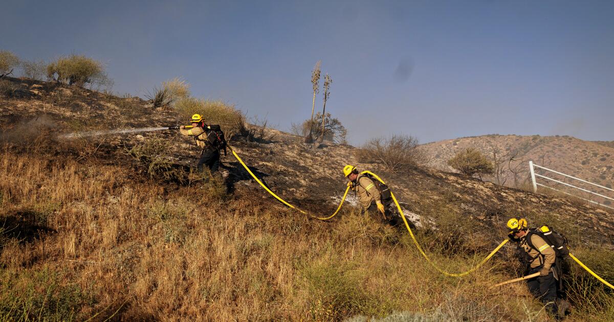
Other areas that experienced damaging mudslides and mudflows included Studio City, Tarzana, Baldwin Hills and Hacienda Heights.
A large accumulation of rain during a storm is enough to trigger a landslide, especially in certain neighborhoods where human modifications to the landscape and drainage can contribute to increased risk.
“Most of the slides that we've seen, that have been in the news, have occurred in built environments,” said Matt Thomas, a research hydrologist with the USGS landslide hazards program.
“And those are hillsides that could have conditions that predispose them to more landslides than normal,” Thomas said. “Therefore, there may be slopes that are too steep, underdeveloped fill that erodes where a house sits. “You can have drainage conditions on the site that channel water… into areas that end up eroding and therefore causing landslides.”
Mudflows also occurred in anticipated locations, such as Malibu Canyon and along the Pacific Coast Highway. These areas suffer frequent rock and earth slides when it rains.
A car drives through a rainwater-filled street near Beverly Glen Boulevard during a storm in the Hollywood Hills in early February.
(Ringo Chiu / For The Times)
But the intensity of the rains was not epic
It might have felt like the rain was heavy in the hills. But by historical standards, and in relative terms, it wasn't falling at epic rates.
By quantifying intensity, hydrologists measure hourly rainfall rates.
One inch of rain per hour is considered heavy. But, Thomas said, it was rare to see that kind of intensity during the recent storm.
As a result, no widespread landslides or mudflows were observed on the mountain slopes of the region. Instead, the landslides appear to have been limited to neighborhoods that were already at higher risk.
“That's probably what made the difference between the news reporting lots of mudslides in neighborhoods and widespread mudslides across the mountain ranges into a much more widespread event,” Thomas said.
The ingredients of landslides
Criteria for the causes of widespread landslides in Southern California were first documented in the 1970s, Thomas said.
Start with at least 10 inches of seasonal rain. Downtown Los Angeles didn't surpass that threshold until Feb. 4, the first big day of the storm.
The second ingredient is a minimum rainfall rate: at least a quarter of an inch per hour. However, that standard is outdated and a higher hourly rainfall rate is likely required for widespread landslides with larger impacts.

Standing on burned ground, a firefighter waits for crew members to bring water to put out hot spots on Highway 371 after the Highland Fire on October 31, 2023 in Aguanga.
(Gina Ferazzi / Los Angeles Times)
The scarcity of wildfires has helped
The fact that last winter was wet for California, which helped keep wildfires to a minimum, is also helping to avoid serious mudflows this winter.
That was not the case in 2018. In December 2017, the Thomas Fire, the largest in Southern California history, burned 281,893 acres in Ventura and Santa Barbara counties, including burning all of the watersheds above Montecito and Carpinteria.
Then came a period of very heavy rain in early January 2018. Rapid flows of mud and debris poured down from the hills, killing 23 people, destroying 130 homes and causing hundreds of millions of dollars in damage.
Scientists refer to this subset of landslides as debris flows, in which water falls and mixes with mud and debris, as well as rocks and branches. In the post-fire Montecito debris flow, the event began as a flash flood that began picking up mud and other debris, including rocks that were larger than cars.
A report written by Nina Oakley, now a geohazards climatologist at the California Geological Survey, and Marty Ralph of the Center for Western Climate and Aquatic Extremes at the Scripps Institution of Oceanography, said there was a “period of very heavy rainfall” that It was the main trigger during the 2018 storm.
Also of vital importance is how the soils above the neighborhood changed due to the wildfire, causing “water-repellent soils” to develop. As a result, “rainfall runoff increases dramatically in these areas compared to unburned areas.”
Additionally, an accumulation of weeks of prior rain in a burned area is not necessary to precede a debris flow.
What happens when the rains are intense?
Exactly five years to the day of the deadly Montecito debris flows, there was another round of heavy rain in that region. About 7,000 landslides occurred in the field, said Jason Kean, another research hydrologist with the USGS landslide hazards program. Significant damage was caused in the cities by illuminated waters. The January 2023 storm caused more than $80 million in damage to Santa Barbara County.
That storm had both ingredients to cause landslides in the countryside. It pushed Santa Barbara to have more than 10 inches of accumulated seasonal rain, according to the National Weather Service, and There were rainfall rates of 1 inch per hour, Kean said.

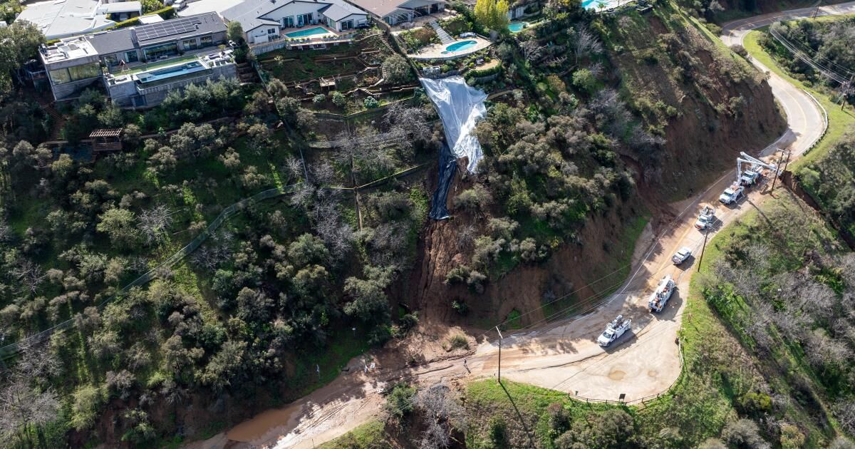
An aerial view shows three large homes in Dana Point on a bluff where a landslide occurred in early February.
(Allen J. Schaben/Los Angeles Times)
Landslide risk could increase
As we approach the second half of winter, Southern California is now firmly above the baseline of 10 inches of rain this wet season. Downtown Los Angeles has recorded 15.8 inches of rain since October 1; that's already more than its average annual precipitation of 14.25 inches.
“Obviously, we've hit that 10-inch mark for the winter season. And then [in terms of future landslide risk] “We're really looking for heavy, high-intensity rain to start,” Kean said.
One key factor that could pose an increased risk in future storms is a “narrow band of cold frontal rain,” or NCFR for short. “This is basically a weather element that can produce high-intensity rainfall,” Thomas said. An NCFR was a factor in the deadly 2018 Montecito landslides.
As for our recent early February storm, an NCFR developed, but it didn't produce particularly heavy rain, Thomas said. But if he had, “he would have been No. 2 in the double of producing landslides,” he added.
People might object to scientists' observations that the last storm was not particularly intense. But it can be easy to combine “how much rain accumulated over the course of the storm with how hard it rained at any given time,” Thomas said.
“What we really need for that widespread landscape collapse – in terms of landslide generation – is that we need that antecedent rainfall and we need the high intensity to fall shortly afterward,” he said.
In terms of landslides, “it's a double whammy,” Kean said. “He wets things and then hits them hard with a blast.”
During the early February storm, “things definitely got wet. …But fortunately the initial burst was not so big as to make the problem worse,” he added.

Animated infographic shows how debris flows and deep landslides occur
Deep landslides will be a bigger concern later in the season
There is also a subset of slides known as “deep landslides,” which involve slides greater than 15 feet deep, which can be particularly destructive and can occur even on a dry day. There were two memorable deep landslides during and after an epic rainy season in 2005.
The first occurred on January 10 of that year, killing 10 people in La Conchita, a community on the coast of Ventura County. The landslide occurred at the end of an intense 15-day period of rain.
Another occurred in June in Laguna Beach's Bluebird Canyon after a period of heavy rain from December through the previous February. No rain fell immediately before the slide, which destroyed 17 homes and severely damaged 11 others.
The rainy year that ended on June 30, 2005 was the wettest in the last generation. An astonishing 37.25 inches fell in downtown Los Angeles that year, even more than the memorable 1997-98 El Niño season, when 31.01 inches of rain fell, and the wet year 2022-23, when 28 fell. .4 inches. Those are the only three wet years in the past 26 seasons in which annual precipitation was more than 10 inches above average in central Los Angeles.
Deep landslides can occur where the bedrock is very deep and rainwater can seep deep underground. During repeated heavy storms, water can build up and eventually destabilize an entire piece of land, causing it to collapse downhill. They can occur slowly or with astonishing speed.
Generally, in Southern California, deep landslides occur in above-average rainy seasons, Thomas said.