HISTORY IN DEVELOPMENTHISTORY IN DEVELOPMENT,
The storm begins to shut down the southeastern Caribbean amid urgent calls from government officials for people to seek shelter.
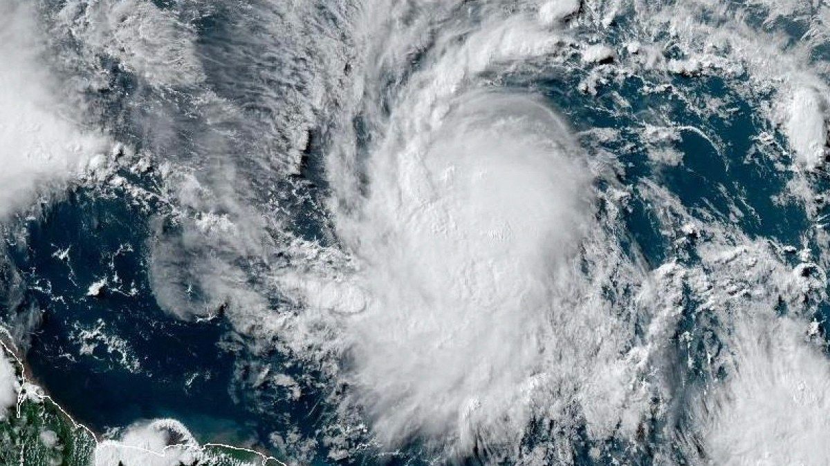
Much of the southeastern Caribbean is on alert as Beryl strengthens into the first hurricane of the 2024 Atlantic season, with forecasters warning of a “very dangerous” Category 3 storm.
The US National Hurricane Center (NHC) said Beryl, churning in the Atlantic Ocean about 675 kilometres (420 miles) east of Barbados, was expected to bring “life-threatening winds and storm surge” by 12:30 GMT on Sunday when it reaches the Windward Islands early on Monday.
Barbados, Saint Lucia, Saint Vincent and the Grenadines and Grenada were under hurricane warnings, while tropical storm warnings or watches were in effect for Martinique, Tobago and Dominica, the NHC said in its latest advisory.
Cars were seen lining up at gas stations in Barbados' capital Bridgetown, while supermarkets and grocery stores were packed with shoppers buying food, water and other supplies. Some families were already boarding up their properties.
Beryl is now only the third Category 3 hurricane on record in the Atlantic in June, after Audrey in 1957 and Alma in 1966, according to hurricane expert Michael Lowry.
“Only five big [Category 3+] Hurricanes have been recorded in the Atlantic before the first week of July. Beryl would be the sixth and the first at this end of the tropical Atlantic,” Lowry published in X.
Devastating wind damage expected
The NHC said that by about 5 a.m. (0900 GMT) on Sunday, Beryl's maximum sustained wind speed had increased to nearly 100 mph (160 km/h) with stronger gusts. It is extremely rare for such a powerful storm to form so early in the Atlantic hurricane season, which runs from early June to late November, experts said.
“Hurricane conditions are expected in the hurricane warning area beginning early Monday,” the NHC said, warning of heavy rains, flooding and storm surge that could raise water levels as much as 9 feet (2.7 meters) above normal.
“Devastating wind damage is expected where Beryl's eyewall moves across portions of the Windward Islands,” the NHC added, indicating that wind speeds in some locations could be 30 percent stronger than listed in its advisory.
Beryl is likely to pass just south of Barbados early Monday and then head out into the Caribbean Sea as a major hurricane on its way to Jamaica. It is expected to weaken by midweek, but will remain a hurricane as it heads toward Mexico.
Forecasters warned of a potentially deadly storm surge in areas where Beryl will make landfall, with up to 6 inches (150 mm) of rain in Barbados and nearby islands.
The US National Oceanic and Atmospheric Administration (NOAA) said in late May that it expects this year to be an “extraordinary” hurricane season, with up to seven storms of Category 3 or higher.
The agency cited warm temperatures in the Atlantic Ocean and conditions associated with the La Niña weather phenomenon in the Pacific as the cause of the expected increase in storms.
Extreme weather events, including hurricanes, have become more frequent and devastating in recent years as a result of climate change.