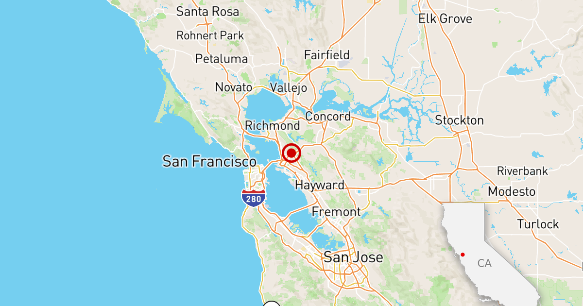
The Eaton Fire was moving west of Altadena even sooner than previously believed, a state-commissioned report confirmed this week, raising more questions about why it took so long for Los Angeles County officials to order evacuations in the neighborhood where 18 people died.
The fire broke out on January 7 at 6:18 p.m., driven by hurricane-force Santa Ana winds that pushed flames into neighborhoods at high speed. Within about an hour, the county issued evacuation orders for many of the foothill communities near the fire's origin, including the east side of Altadena. But as The Times first reported in January, evacuation orders for western Altadena were not issued until after 3 a.m., long after the fire threatened the area. Evacuation warnings for the area were never issued.
All but one of the 19 deaths from the Eaton Fire occurred in west Altadena.
The Fire Safety Research Institute report, released Thursday morning, does not discuss why alerts were delayed, but it provides the most detailed timeline yet on the night of the fire, including new timestamps that show there were signs the fire was moving west of Altadena nearly six hours before the area received any evacuation alerts.
The report notes that there were “fires spreading westward” as early as 9:30 pm on January 7, pointing to several fire spots west of the fire's origin.
At 10:22 p.m., and for the next hour, there were multiple radio calls reporting that the fire was spreading west toward North Lake Avenue, according to the report. Just before 11 p.m., as The Times previously reported, there were signs of flames in western Altadena, more than four hours before officials issued evacuation orders for that area.
The report states that the winds changed shortly after 11 p.m., which “could have helped spread the flames that had reached the foothills and the northeast section of Altadena to the south and west across Altadena in the early hours of January 8, 2025.”
Several firefighters previously told The Times that they didn't notice the wind moving west until around 2 a.m., but the report shows the signs were there earlier, both in wind measurements and in 911 calls.
Pasadena Fire Chief Chad Augustin told The Times in May that around 2 or 3 a.m., command staff at the Rose Bowl began receiving “good information” from crews on the ground that the winds were shifting and pushing the fire westward, requiring more evacuations, but he couldn't remember the exact time.
Between 11:18 p.m. and 12:17 a.m., the document identified at least 10 fire reports on the western flank of the fire, showing its progress toward Lake Avenue.
Why the county did not evacuate western Altadena sooner has been a topic of major concern among residents and an issue the county has not yet fully addressed.
A county report on fire evacuations last month found that there was a recommendation to issue broader evacuations to the west around midnight, but for unknown reasons it was not heeded. It would be another three hours before incident commanders ordered additional evacuation orders.
While the new state report doesn't provide new details about that midnight recommendation, it does offer new insights into how quickly the fire moved, particularly how early embers from the Eaton Fire flew west of Altadena, ultimately devastating the community.
The highly anticipated state report is the first of two from the nonprofit security research organization. It provides the most comprehensive examination yet of how and when firefighters responded to the Eaton and Palisades fires.
Although the paper doesn't provide much analysis, focusing on the facts of the conditions, preparations and response, the findings were clear: “Embers contributed to the rapid expansion,” Derek Alkonis, one of the authors, said at a news conference Wednesday, ahead of the report's release.
The delayed evacuations have prompted scrutiny from public officials and Altadena residents over the Los Angeles County Fire Department's handling of the wind-driven fire.
Michael Gollner, an associate professor of mechanical engineering at UC Berkeley who directs its Fire Research Laboratory, said the timeline provided in the report is an important starting point for understanding what happened during the response to the fire.
But he noted there was still little information on some crucial details: What was the chain of command on the first day of the Eaton fire? How was the information shared? What other issues were incident commanders facing at the same time that could have affected evacuation decisions?
“That's what's really important, how that information was transmitted and how much they knew [the fire] “It was spreading to this area,” Gollner said. “There is much more to come and much more we need.”
Other reports already published about the fires carried out by Los Angeles County and the city received criticism from residents for being limited in scope.
Last month, a report commissioned by Los Angeles County found that a general lack of planning, poor communication, understaffing and chaotic conditions contributed to ill-timed evacuation orders as the Eaton Fire swept through Altadena. But the report was widely criticized for failing to answer key questions about evacuation failures, including why county officials did not send evacuation alerts west of Altadena until 3:25 a.m. or later.
Details from the state report shed more light on what ultimately caused county firefighters to expand evacuations to include western Altadena.
At 10:50 p.m., a resident called to say the fire was visible from his home on East Calaveras Street in west Altadena. Almost exactly an hour later, a Los Angeles County battalion chief reported a structure fire at Glenrose Avenue and West Loma Alta Drive, even further west of Altadena, according to the report.
Shortly before 2 a.m., an official drove west toward Lake Avenue at East Altadena Drive, trying to reach Fair Oaks Avenue in west Altadena to “investigate the extent of the fire's spread” and encountered intense conditions, according to the report.
“He was unable to continue as he encountered zero visibility, intense heat, and had serious concerns about becoming trapped,” the report said.
Around the same time, county firefighters were defending structures on East Mount Curve Avenue near Lake Avenue. They were forced to leave after 30 minutes due to the danger posed by erratic winds.
Despite all of these signs of increased fire activity in western Altadena, it would still be more than an hour before the evacuation order was issued.
Governor Gavin Newsom commissioned the Fire Safety Research Institute, based in Columbia, MD, to conduct an investigation about a month after the Palisades and Eaton fires killed 31 people and destroyed 16,000 structures across Los Angeles County. Researchers and engineers from the institute, which also conducted post-incident analysis for the state of Hawaii after the Maui fire in 2023, deployed to Southern California to gather evidence to “build a comprehensive timeline of events and conditions that will inform analysis of response effectiveness.”
Thursday's report provides a timeline of how the fires progressed and analyzes the actions of state and local officials, weather conditions, emergency response and firefighting. It also includes a review of 10 other fires that occurred in Southern California the same month as the Eaton and Palisades fires.
The report further captures the chaos and erratic nature of the wind-driven Eaton Fire and the challenges crews on the ground faced battling the inferno. According to the report, the fire was not only moving west earlier than previously reported, but was also spreading east simultaneously.
Shortly before 1 a.m., crews on different ends of the fire requested more resources, calling for help both east and west of the fire's origin. Authorities received similar reports about the severity of the fire between 1:11 a.m. and 3:13 a.m., reporting homes on fire in the northern Sierra Madre, as well as east and west Altadena.
The embers transformed what began as a forest fire into a full-blown urban conflagration. This likely made evacuations difficult, experts said.
When firefighters are considering evacuations, they typically look at wind speed and direction, topography and fuel type to guide them, said Matt Rahn, founding director of the wildland-urban interface program at Cal State San Marcos and research director at the Wildfire Conservancy.
But in a fast-moving inferno where embers dart miles from the fire's start and ignite spot fires, “it makes it very difficult to evacuate communities and predict where an evacuation should occur,” Rahn said.
“When all of a sudden you have spot fires starting literally miles away from the fire front, it creates a whole new challenge,” Rahn said. “You're not only worried about what's happening here, but also about other incidents that could turn into larger fires or, in the case of the Eaton fire, an urban conflagration. They are very difficult to predict and are becoming more common in the types of fires we experience.”
The second phase of the report, expected to be released in mid-2026, will build on the information contained in the first report to provide analysis and details on the effectiveness of officials' efforts to prevent the fires and alert residents. The reports will not delve into the cause of the fires.
Art Botterell, former senior emergency services coordinator for the California Governor's Office of Emergency Services, said the timeline was a necessary first step. But while the timeline approach can be useful, Botterell said, it also has limitations.
Botterell said trends and variations in demographics, urban planning, workforce development and infrastructure development and maintenance could be harder to detect in a series of snapshots over a relatively short period.
“New data is always useful, but usually the blind spots are in the questions we don't ask,” Botterell said. “Much will depend on the depth, perspective and independence of the analysis that follows.”
Times staff writer Jenny Jarvie contributed to this report.