The strongest winter storm of the season moved toward Southern California on Sunday and was expected to bring powerful wind gusts, near-record rainfall and life-threatening flash flooding to the region through Tuesday.
The slow-moving atmospheric river was still gaining strength Sunday afternoon, and the National Weather Service in Oxnard warned that “all systems are in place for one of the most dramatic weather days in recent memory.”
Palm trees blown by the wind during a storm in Santa Barbara on Sunday. Hurricane-force winds battered seas off California, while heavy rain increased the risk of flooding from San Francisco to San Diego as another powerful Pacific storm arrived.
(Bloomberg via Getty Images)
Forecasters said the worst of the storm now appears to be focused on the Los Angeles area, where the system could stall for an extended period over the next few days. The storm could dump up to 8 inches of rain on the coast and valleys, and up to 14 inches in the foothills and mountains. Snowfall totals of 2 to 5 feet are likely at elevations above 7,000 feet.
“Los Angeles County now appears to be the area of greatest concern, where the heaviest rain will last the longest,” said Ryan Kittell, NWS meteorologist in Oxnard.
The storm is expected to “bring a multitude of dangerous weather conditions to the area,” forecasters said. Warnings and evacuation notices have already been issued in parts of Ventura, Santa Barbara, Monterey and Los Angeles counties, including parts of Topanga near the Owen Fire scar and the La Tuna Canyon area in Sun Valley near the Land fire scar.
Burn scars are subject to increased risk from flooding and debris flows, Mayor Karen Bass said in a statement. She urged Angelenos to heed all evacuation orders.
“Keeping people safe is our top priority and in conditions like this, lives can be lost,” Bass said.
In addition to the high risk of flash flooding and excessive rainfall, the storm also has the potential to generate damaging winds. That includes gusts up to 70 mph in San Luis Obispo and Santa Barbara counties through 6 p.m. Sunday, with isolated gusts up to 90 mph possible in mountainous areas.
Ventura and Los Angeles counties could see wind gusts up to 50 mph between 1 p.m. and 1 a.m., with isolated gusts up to 70 mph in mountains and hills. The Ventura River is expected to rise and reach flood stage around 11 pm Sunday night.
Kittell said the storm could impact Monday morning travel, including flooding on freeways and major delays throughout Los Angeles County.
“If someone has the opportunity to work remotely on Monday, that's definitely the day to do it,” he said.
The storm crossed northern and central California before heading south.

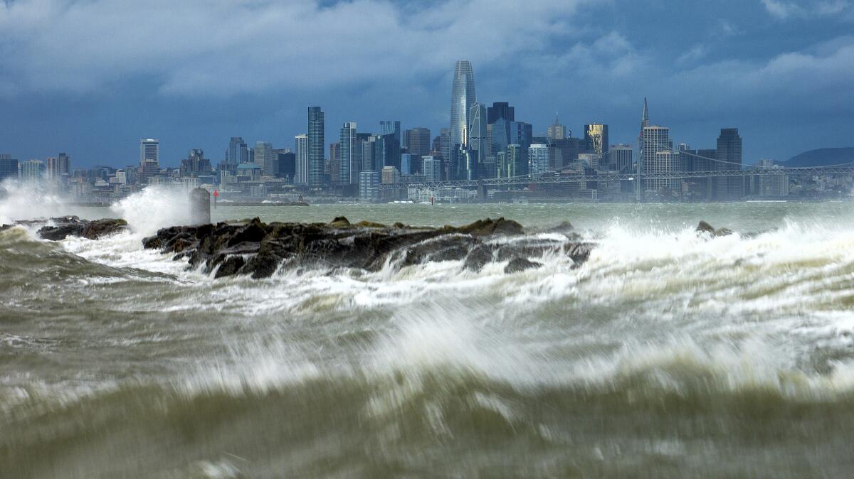
Waves crash over a breakwater in Alameda, California, with the San Francisco skyline in the background on Sunday. Strong winds and heavy rain are affecting the region.
(Noé Berger/AP)
In Northern California, monster winds and downpours began flooding the region Saturday night, and the worst of the weather accelerated early Sunday. Thousands of people were without power late in the morning, and officials scrambled to respond to downed trees and power lines across the Bay Area and Central Coast, as well as growing concerns about the surge. of the floods.
In Sonoma County, a tree fell on a home early Sunday morning; In Palo Alto, a huge tree blocked the eastbound lanes of the Oregon Expressway. Downed power lines closed a stretch of State Road 1 in San Mateo County, and in San Francisco, downed lines forced traffic to be diverted.
Some of the strongest winds early Sunday were recorded in the Big Sur area: up to 88 and 85 mph, said Sarah McCorkle, a meteorologist with the National Weather Service in the Bay Area. But gusts had also reached up to 60 mph in the East Bay and were expected to remain a major threat throughout the day, with a high wind warning in effect for much of the state through Sunday night or Monday. .
“This isn't over yet,” McCorkle said early Sunday morning.
In San Jose, city officials declared a state of emergency ahead of expected flooding along the Guadalupe River, caused by heavy rains in the Santa Cruz Mountains, where 6 inches of rain is expected through Monday. Officials ordered the evacuation of people living along the river banks and offered free transportation and shelter. The river is forecast to peak at more than 11 feet, nearly 2 feet above its flood stage.

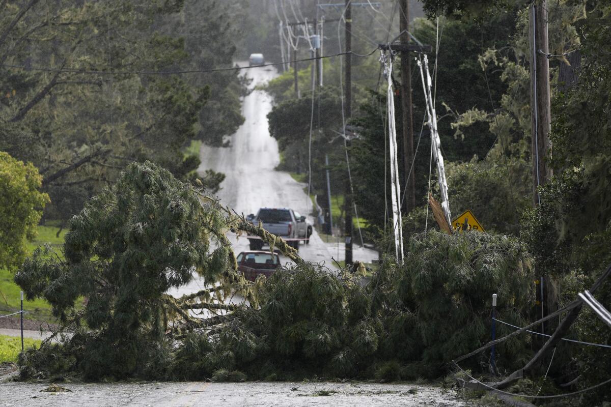
Downed trees and power lines block a road in Pebble Beach, California, on Sunday. Strong winds and heavy rain are expected to batter California's central coast, as a second atmospheric river in days threatens to soak the state and cause flooding and mudslides. The storm made landfall Saturday in Northern California and is expected to cause showers through Tuesday as it moves up the coast toward San Diego.
(Ryan Sun/AP)
The Carmel River at Robles Del Rio in Monterey County is also expected to flood, reaching nearly a foot above its flood stage of 8.5 feet Sunday night, according to the Nevada River Forecast Center. California.
Although the Bay Area and Central Coast have seen some significant impacts, “it will be a different story when the storm moves into Southern California,” said Daniel Swain, a climate scientist at UCLA.
“This will have a broader contiguous band of heavy rain developing from about Santa Barbara County eastward, and it will be very slow moving,” Swain said during a briefing Sunday.
He added that “there are some early indications that it could stop Monday into Tuesday,” meaning the storm could persist over the Los Angeles metropolitan area.

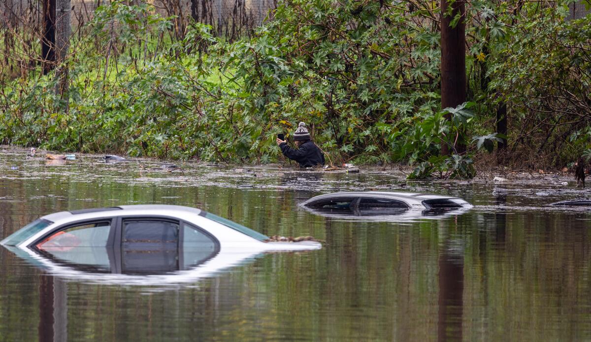
A man swims chest-deep in floodwaters with his cellphone near submerged cars in the 2300 block of West Willow Street in Long Beach on Thursday after rain flooded several areas of the city.
(Allen J. Schaben/Los Angeles Times)
Areas south and east of Los Angeles also won't be spared. Conditions in Orange County, the western Inland Empire and the San Bernardino Mountains were expected to deteriorate Sunday into Monday as the storm moves toward San Diego and the Mexican border, according to the National Weather Service in San Diego.
“Rainfall intensity will only increase in these areas on Monday and life-threatening flash flooding will be possible. “From Monday night into Tuesday, the axis of the moisture column begins to move further south and east, reaching Riverside and San Diego counties,” the agency said.
Rainfall rates in the southernmost part of the state will be modest (up to 0.30 inches per hour), but the unrelenting nature of the rain will continue to lead to impressive totals through Tuesday, the agency said.
That includes up to 7 inches in the Santa Ana Mountains; 5 inches in Orange County; 4 inches in Riverside County mountains; 2 inches in Apple and Lucerne valleys; 1.5 inches in the Coachella Valley and 0.75 inches in the deserts of San Diego County. San Bernardino County mountains could see up to 11 inches on south-facing slopes.
Regional utilities, including California Edison and the Los Angeles Department of Water and Power, were preparing to respond to service outages and downed power lines. More than 170,000 people were without power across the state as of noon Sunday.
“We are taking this storm system very seriously to ensure we are accurately prepared,” said Edison spokesman Jeff Monford. “Our meteorologists discuss current conditions and the forecast with the teams that handle network operations and management so we can place teams in the most affected areas. “We do this so crews get to the scene before roads are closed due to flooding or ice.”
The LADWP “will closely monitor the storm system and respond accordingly, with the ability to schedule crews to be available 24 hours a day,” the utility said in a statement. It has also beefed up staffing at call centers to respond to potential increases in calls from customers without power.
“During the storm, winds could topple large objects, such as trees, or cause palm branches and leaves to hit power lines, potentially causing power outages,” LADWP said. “This is especially true when rain supersaturates the soil, causing it to loosen and uproot trees.”
In addition to downed trees, flooding and water intrusion into underground electrical systems can also cause power outages. Repairs may be slower if the affected equipment is underground and crews must go from vault to vault to identify the source of the damage before repairs can be made.
Utility companies urged people to be careful of downed power lines, which can electrify puddles, wet grass and surrounding areas.
“Always assume that a downed wire is energized,” Edison said. “Stay away and call 911 immediately.”


