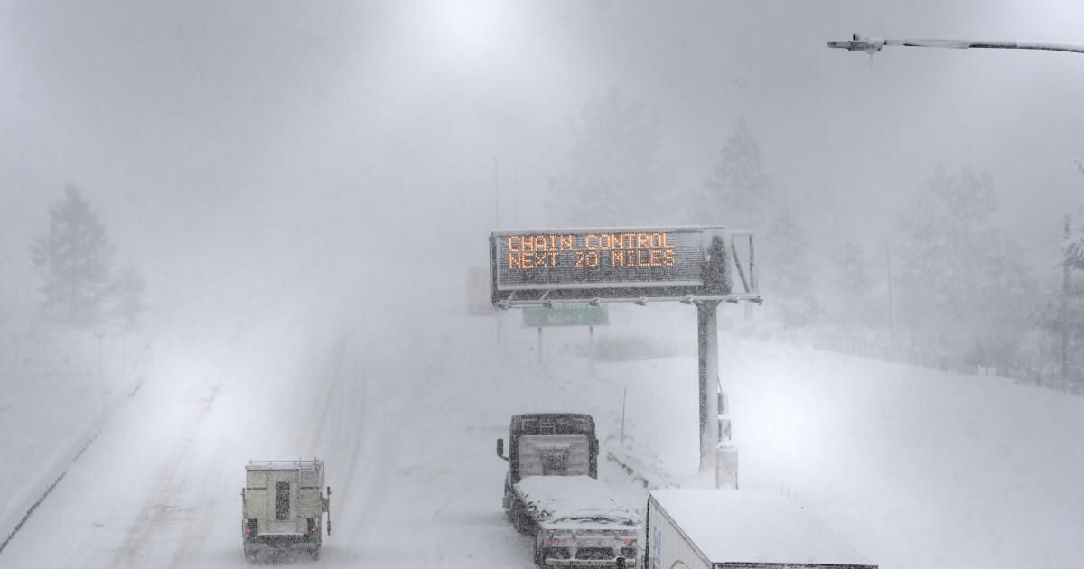
California's most powerful snowstorm of the winter sent gusts of up to 190 mph into the Sierra Nevada, and heavy snow and strong winds forced officials to close some roads in the Lake Tahoe and Mammoth Mountain areas.
Roads that were forced to close overnight Saturday morning included a 50-mile stretch of Interstate 80 between Drum Forebay and the Nevada state line and a 50-mile stretch of Highway 395 north of Mammoth Lakes to Bridgeport.
Highway 395 between Mammoth Lakes and Southern California remained open as of Saturday morning, but weather conditions were hazardous due to high winds and heavy rain in some areas. On Friday afternoon, a truck overturned due to high winds in the Olancha area of Inyo County, the California Highway Patrol said.
On Friday, on Interstate 80 over the Sierra, several vehicles spun and a large truck came to rest.
A 190 mph gust was detected Friday night in Palisades Tahoe at an elevation of 8,700 feet, according to the National Weather Service. Forecasters warned of extreme avalanche danger in the Tahoe region of the Sierra backcountry through Sunday afternoon.
Around Mammoth Mountain in Mono County, maximum winds reached 114 mph Friday afternoon.
The California record for fastest wind gust verified by the National Oceanic and Atmospheric Administration was 199 mph on February 20, 2017, on Ward Mountain, also known as Ward Peak, in Palisades Tahoe.
Forecasters urged people to stay where they are unless there is an emergency, and warned that it could take time for plows to excavate communities. Forecasters say the storm, which could dump up to 12 feet of snow in the highest elevations of California's most powerful mountain range by Sunday, could result in one of the 10 snowiest days in the central Sierra since 1970.
The Sierra ridge overall is expected to receive 6 to 10 feet of snow; Mammoth Lakes, 2 to 4 feet; and the Tahoe Basin, 3 to 6 feet. Snow could fall at a rate of 1 to 6 inches per hour, the weather service said.
Mammoth Ski Resort was forecasting a high of 15 degrees on Saturday and, in addition to the blizzard, was forecasting “storm snow,” where lightning can appear within a blizzard.
“Light, fluffy snow will be easily blown away, creating darkening conditions with near-zero visibility at times,” the weather service office in Reno said. For those venturing out, “pack an emergency kit and prepare to be stranded in your vehicle for an extended period.”
Sierra ski resorts reported Friday that they were forced to close at least some sections of their mountains, or had to shut down operations entirely, due to the intensity of the snowstorm. It will take time to unearth the chairlifts, they said.
Life-threatening blizzard conditions were expected through Saturday morning, according to the National Weather Service office in Reno, which issued a rare blizzard warning for this storm that will last through Sunday morning. The blizzard warning extends from Lassen Volcanic National Park in Shasta County to Kings Canyon National Park in Fresno County.
Blizzard warnings for the Sierra Nevada are issued only once a year or once every two years.
Snow showers in the Sierra are expected to continue through Sunday and Monday, with more chances for snow on Wednesday.
“That break we were hoping for Tuesday may not be much of a break for the Sierra,” the weather service office in Reno said. “The Sierra could see up to 6 inches of snow in the valleys, and up to another foot near the crest, between Tuesday and Wednesday.” After that, “drier weather appears to return Thursday and into the weekend,” the weather service said.
Hundreds of customers in the Tahoe area were without power for at least a period of time Friday night and early Saturday, according to the Truckee Donner Utility District and Liberty Utilities.
Other areas of California are also expected to be affected by the severe winter storm. A stretch of Interstate 5 in Siskiyou County, near the Oregon border, could receive more than 1 foot of snow.
And Highway 101 in Mendocino, Humboldt and Del Norte counties could see snowfall. Highway 101 at Ridgewood Summit in Mendocino County could receive up to 1 foot of snow; at Prairie Creek Summit in Humboldt County, up to 1.5 feet; and south of Crescent City in Del Norte County, about a half-foot of snow.
Yosemite National Park was ordered closed starting Friday and its visitors were ordered to leave by noon. The park will remain closed until at least noon Sunday and its closure could be extended.
Between 6 and 12 inches of snow could fall in Yosemite Valley, the most popular part of Yosemite National Park, the National Weather Service office in Hanford said. A winter storm warning will be in effect there from Saturday morning through Sunday morning.
A heavier blizzard warning was already in effect for the rest of Yosemite National Park outside of Yosemite Valley, lasting through Sunday morning.
Between 2 and 3 feet of snow could fall at the Big Oak Flat entrance to Yosemite National Park along Highway 120, a route often taken by travelers from the San Francisco Bay Area.
Along Highway 41, a route into the park often taken by those coming from Fresno and Southern California, 3 to 5 feet of snow could fall at the park entrance around Mariposa Grove. At the historic Victorian-era Wawona Hotel, 3 to 6 feet of snow could fall.
In the Sacramento Valley, gusty winds could cause power outages and downed trees into the early hours of Saturday.
The winter storm was expected to be milder in Southern California. The wettest period of the weekend was expected for Saturday, but there is still a chance of rain on Sunday.
Still, there could be “isolated, brief bursts of heavy rain likely through Saturday night,” primarily on coastal hills and slopes, the weather service office in Oxnard said. There is a potential for landslides and rock slides along canyon roads and under steep slopes, and for continued ground movement in recent landslide areas.
For the weekend storm, downtown Los Angeles could receive 0.6 inches of rain; Long Beach, 0.44 inches; Pomona, 0.74 inches; Pasadena, 1.33 inches; Santa Clarita, 0.77 inches; Oxnard, 0.65 inches; and Santa Barbara, 0.92 inches.
San Diego could reach up to 0.2 inches; Irvine, San Clemente and Riverside could reach up to 0.3 inches; Anaheim, up to 0.4 inches; Ontario and Temecula, up to 0.7 inches; and San Bernardino, up to 1 inch.
The San Francisco Bay area was facing thunderstorms Friday night, which were expected to continue into Saturday, with increasing winds. Gusts up to 50 mph are possible through Saturday morning. Overall, cities in the Bay Area were forecast to receive between 1 and 1.5 inches of rain through Sunday.
Four people were injured in San Francisco on Friday night after a tree fell on their car at Golden Gate Avenue and Laguna Street, fire officials said.