Nearly 10 years ago, Andrew Thorpe received a text message from the crew flying a small aircraft: they had detected a new methane hotspot.
Thorpe drove along winding dirt and mountain roads in a rented, unwieldy SUV near the Four Corners region of the southwestern United States. When he arrived at the location he had been told to see from the plane, he pulled out a thermal camera to scan the plume. Sure enough, methane was seeping from the ground, probably from a leak in an oil pipeline.
He found a sign sticking out of the desert with the phone number for a gas company, so he called them. “There was a very confused person on the other end of the phone,” Thorpe said. “I tried to explain to them why I was calling, but this was many years ago when there really wasn’t any technology that could do this.”
Over the years, the job has earned Thorpe some unwanted attention. “I did some driving surveys in California … A rent-a-cop was very suspicious of me and tried to scare me,” Thorpe said. “If you put a thermal camera on a public road and point it at a tank that’s beyond the fence, people are going to get nervous. I’ve had some oil and gas workers boo me, but that’s normal.”
Today, Thorpe is part of a group at the forefront of greenhouse gas monitoring at NASA's Jet Propulsion Laboratory in La Cañada Flintridge. For more than 40 years, JPL's Microdevices Laboratory has developed specialized instruments to measure methane and carbon dioxide with extreme precision.
The instruments, called spectrometers, detect gases based on the colors of sunlight they absorb. Earlier this year, a team of researchers from JPL, Caltech, and the nonprofit Carnegie Science He was selected as a finalist for a NASA award to put the technology into orbit.
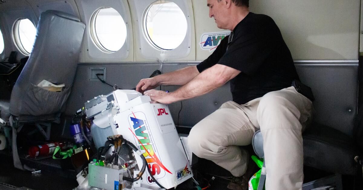
JPL technicians are working on an Airborne Visible/Infrared Imaging Spectrometer, or AVIRIS, that will be mounted on an aircraft to search for methane and other greenhouse gases.
(Myung J. Chun/Los Angeles Times)
If chosen for the satellite mission, the team’s carbon investigation, called Carbon-I, would launch in the early 2030s. Over the course of three years, Carbon-I would continuously map greenhouse gas emissions around the world and take daily snapshots of areas of interest, allowing scientists to identify sources of climate pollution such as power plants, leaking pipelines, farms and landfills.
While there are already several satellites monitoring these gases, Carbon-I's resolution is unprecedented and would eliminate any guesswork when determining where the gas was emitted. “There's no denying it anymore: Once we see a plume, there's no other potential source,” said Christian Frankenberg, Carbon-I co-principal investigator and professor of environmental sciences and engineering at Caltech.

Caltech professor Christian Frankenberg, co-principal investigator of the proposed space-based Carbon-I emissions monitoring system, looks at an AVIRIS monitor under construction in a JPL laboratory.
(Myung J. Chun/Los Angeles Times)
Carbon-I’s maximum resolution of 30 meters “is very high resolution from space. It’s an incredible resolution to be able to get,” said Debra Wunch, a professor at the University of Toronto who studies Earth’s carbon cycle and is not involved in the Carbon-I proposal. “It could tell us a lot more about the exact source of emissions … This would be revolutionary. You could see individual smokestacks, even individual parts of landfills.”
Historically, monitoring greenhouse gas releases from individual emitters has been challenging, as both carbon dioxide and methane are colorless and odorless. Therefore, scientists have often had to rely on adding up self-reported values and estimates from research. For example, to estimate how much methane cows produce, scientists would have to determine how much methane a cow releases and multiply it by the total number of cows on Earth.
“If you look at international policies … they’re all based on these bottom-up inventories right now,” said Anna Michalak, a co-principal investigator at Carbon-I and founding director of the Carnegie Climate and Resilience Hub at Carnegie Science. “We need to get to a point where … we actually have an independent way of tracking what the emissions are.”
Carbon-I resolution will also give scientists new access to the atmosphere of the tropics, where clouds currently obscure most forms of satellite surveillance. “It's their Achilles' heel,” Frankenberg said.
From tropical and subtropical forests absorb about a quarter of CO2 Humanity produces As fossil fuels are being burned, accurate data from this region of the planet is urgently needed.
Satellites currently orbiting Earth with lower resolution can't see through the tiny gaps in cloud cover. They see only a blurry average of the cloudy and clear spots in the sky for each pixel. Carbon-I, with an area of each pixel nearly 50 times smaller than that of most other satellites, can see the gaps and take measurements through them. April 2024 DocumentFrankenberg, Michalak and their collaborators estimated that Carbon I would be able to see beyond the clouds in the tropics 10 to 100 times more frequently than its predecessors.
“Carbon-I will allow us to see things that people don't know about,” said Thorpe, who left behind his days as a graduate student pointing thermal cameras at gas leaks and now works as a research technologist in the Microdevices Laboratory. “It's going to open up a whole new field of science.”
JPL's airborne greenhouse gas monitoring program dates back decades, but the field of space monitoring is still fairly new. In early 2016, NASA Headquarters reached out to the JPL team. Explosion at Aliso Canyon gas storage facility near Porter Ranch, and NASA wanted the team to check it out.
The team flew over the site in a variant of a 1960s spy plane for three days over a month as the Southern California Gas Co. struggled to contain the leak. At the same time, NASA's Goddard Flight Center in Maryland trained the Hyperion spectrometer on NASA's Earth-observing spacecraft on the leak.
Hyperion was designed to make observations of the Earth's surface and filter out the noise from the atmosphere. Now, they were trying to observe the atmosphere and filter out the surface, and to he first timeScientists observed a man-made methane point source from orbit.
“The Hyperion result was quite noisy, but you could still see the plume,” Thorpe said. “It was really a proof of concept that we could do this from space.”
Even if Carbon-I launches, that doesn’t mean the team will stop putting instruments on planes. From planes, the team can monitor areas of interest at even sharper resolution and for days at a time. Right now, a simpler, more efficient version of the spectrometers that observed the Four Corners leak and the Aliso Canyon explosion is flying a series of missions to monitor emissions from offshore oil rigs in the Gulf of Mexico.

The twin-engine King Air aircraft used by JPL to conduct greenhouse gas monitoring flights at its hangar at Hollywood Burbank Airport.
(Noah Haggerty/Los Angeles Times)
Aircraft missions also give the team a chance to test new and improved spectrometers. “They can be repaired and upgraded,” said JPL engineer Michael Eastwood, who has worked with the spectrometers for more than three decades and flies them regularly. “You can take more risks, unlike spacecraft that need very mature, well-known, highly reliable spectrometers — we’re not as limited.”
The air crew is also agile. Typically, two crew members sit in the second row of a twin-engine King Air and look at a stack of laptops and instruments with enough buttons to rival the plane’s cockpit. On the screens, they can see real-time GPS data and spectrometer results and coordinate a flight plan with the pilots. The spectrometer, called AVIRIS, short for Airborne Visible/Infrared Imaging Spectrometer, sits in the third row and looks down through a window cut into the floor.
The NASA program for which Carbon-I was selected as a finalist aims to fund space-based Earth science that will benefit society. The team received $5 million to refine their project proposal before a final NASA review in 2025. There are three other finalists, and two will be selected for launch.
This two-step process for selecting missions is new to NASA's Earth science programs and requires JPL to compete with the rest of the scientific community, regardless of its affiliation with the space agency.
“If we talk about money for groceries, [$5 million] “It sounds like a lot of money, but it’s actually a bargain,” Michalak said. “If you think about the fact that you’re committing $300 million to a mission, spending 1.5% of that amount to make sure it’s going to be fabulous and successful is extremely smart.”
In the meantime, the Carbon-I team is focused on proving to NASA that it has the technical know-how to execute the project on time and on budget.
“I think all four missions in the current phase are absolutely worthy science missions,” Michalak said, “and a 50% chance is not bad for a satellite mission.”
Newsletter
Towards a more sustainable California
Receive Boiling Point, our newsletter exploring climate change, energy and the environment, and be part of the conversation – and the solution.
You may occasionally receive promotional content from the Los Angeles Times.