Visitors to Mount Shasta are advised to be aware of the continued risk of avalanches in higher elevation areas, just days after the peak was rocked by a slide so powerful it generated 60-foot walls of snow in its wake.
The avalanche, which one official characterized as a “chilling” event, occurred around 2 p.m. Monday during a multi-day storm in the area.
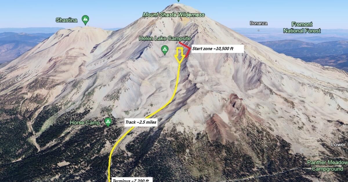
Beginning at approximately 10,500 feet elevation on Green Butte Ridge, the avalanche flowed 2.5 miles down a 3,200-foot vertical drop into the aptly named Avalanche Gulch.
The avalanche gained momentum and leveled trees, “leaving large scars in its wake,” according to a report from the Mount Shasta Avalanche Center. The vertical walls of the avalanche were more than 60 feet deep and included “large flowing debris.”
“The sheer volume of snow being deposited in the depletion zone is mind-boggling,” Nick Meyers, the center's director, said in a statement. “This is a wonderful, fantastic, natural event that will give you chills.”
There were no injuries or damage to critical infrastructure, as the nearby Everitt Memorial Highway was closed during the storm.
“Naturally, we're glad that no one got caught up in this mess,” Meyers said.
The center warned winter visitors heading out on Friday or Saturday morning could trigger an avalanche in the lee, or downwind terrain near the tree line, “especially on steep terrain and exposed”.
As the sun warms the area, the snow will melt, loosen, and possibly begin to slide. Depending on the magnitude, such an event could potentially “knock you over or knock you over, carrying you across dangerous terrain,” the center noted.
The center advised those in the area to be on alert and “watch for crevasses” before traversing avalanche terrain.
The avalanche was caused when a storm slab or corona several feet deep broke off around 10,500 to 11,000 feet in elevation.
Meyers said the center's forecasters initially believed the starting point was higher, around 12,000 feet, but improving visibility in the following days led them to a lower estimate.
The avalanche occurred amid a major storm system that ultimately dropped 2.5 to 3 feet of snow near the treeline of Mount Shasta, “and likely higher,” according to data from the Old Ski weather station. Bowl, which is located on the south side of the mountain. at approximately 7,900 feet elevation.
Snow levels fell to 5,000 feet during the storm.
The avalanche was very similar to another that occurred on Valentine's Day in 2019, according to Meyers. That year, the resulting debris walls were 30 feet deep.