On the first full weekend in September, when the Line Fire was 20,000 acres in size and only 3% contained, one San Bernardino County resident described the sky as “looking exactly as if a nuclear warhead had been detonated.”
At a basic level, this makes sense: By that time, the Line fire had already released more energy into the atmosphere than a dozen atomic bombs. And just as nuclear explosions produce a distinctive mushroom cloud, uncontrolled wildfires can be powerful enough to generate their own weather.
When wood and other vegetation burn, they produce four main compounds: carbon dioxide, smoke (which is a mix of toxic ingredients like carbon monoxide, methane, benzene, and many more), heat, and water vapor. Of these, carbon dioxide is the least relevant to local climate; while it plays an important role in global climate, that is more due to its long lifespan than its immediate potency.
The most notable consequence of smoke emissions is their dangerous effects on human health.
A smoke plume can stretch hundreds or thousands of kilometres as it is carried by wind currents. Smoke aerosols also block and scatter sunlight, causing the surreal “red sun” effect that appears in apocalyptic-looking images on social media; their optical properties also tend to suppress precipitation in downwind locations, which can (in the long term) fuel more fires due to drier conditions.
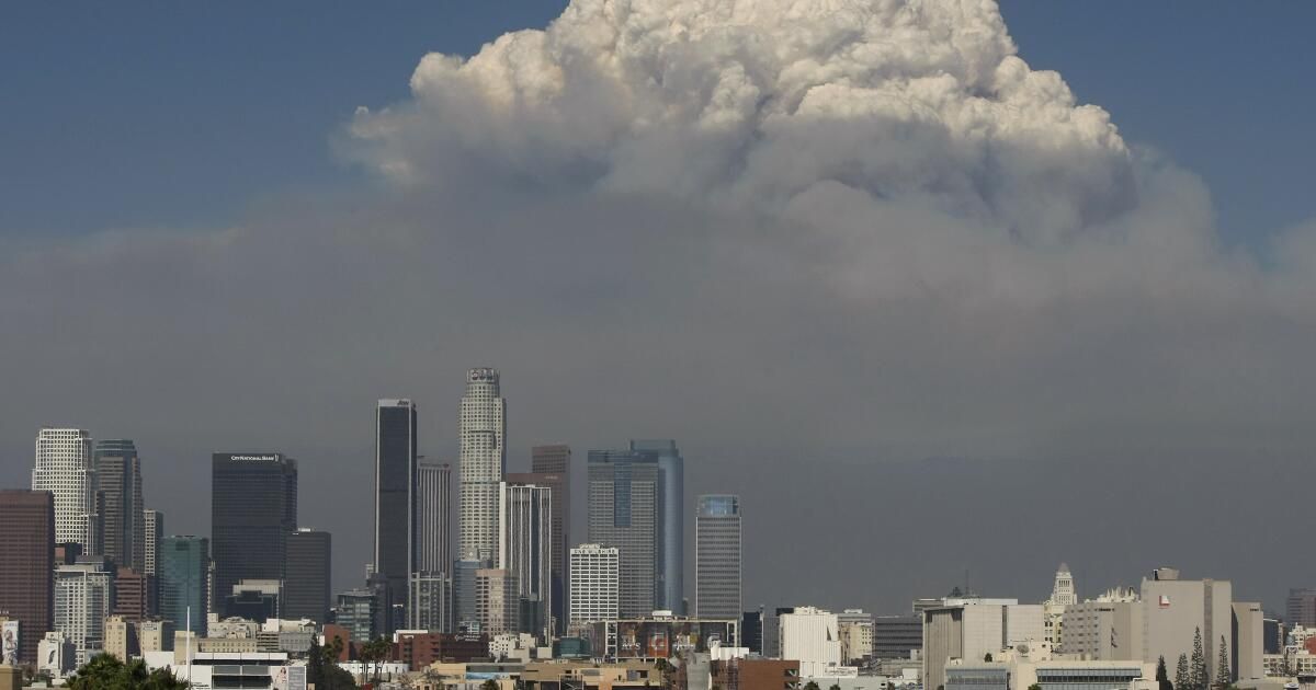
Smoke rising from the Line fires, right, and Airport fires, left, obscures the sun and turns the sky an apocalyptic orange.
(Gina Ferazzi/Los Angeles Times)
The next byproduct of fire is heat: like the burner on a hot air balloon, a wildfire causes the lower layer of the atmosphere to become less dense and therefore rise. As the air above the fire rises, outside air rushes in to replace it, providing the fire with the oxygen that allows it to continue burning.
If the fire is strong enough, it can produce a “firestorm.” This occurs when all the winds surrounding a fire are directed toward the center of the fire, creating a feedback effect: more oxygen produces more intense flames, which in turn attract even more oxygen.
These winds have a mixed effect on the fire's ability to spread: on the one hand, gusts are directed inland, meaning sparks are less likely to be pushed outwards. On the other hand, strong updrafts can catch burning embers and blow them into unburned material, where they can produce “spot fires” several kilometres from the fire line.
In addition, a firestorm can radiate such intense heat that it makes it impossible for firefighters to operate in its immediate vicinity. Firestorms have been observed not only during forest fires, but also during World War II, when bombed cities (such as Dresden, Germany, and Hiroshima, Japan) suffered far more destruction from the resulting fires than from the initial bombing.

The final ingredient is water vapor.
As warm air rises in the atmosphere, the water vapour released by combustion condenses, aided by the presence of smoke particles that act as “condensation nuclei” and allow the water to form droplets. This condensation produces more heat, leading to even more powerful convection, and the end result is known as a pyrocumulus cloud (or, in more extreme cases, pyrocumulonimbus).
These clouds are often a danger signal for firefighters trying to contain the blaze, not only because they indicate that the fire is gaining strength, but also because the dangerous conditions and low visibility within the cloud prevent the use of aircraft to fight the fire. In addition, these clouds can produce frequent lightning strikes that cause new fires in the area.
One advantage of pyrocumulus clouds is that they can produce rain, which in some cases will put out the same fire that started it. However, depending on wind conditions, this rain sometimes evaporates before reaching the ground due to the warm, dry environment surrounding the fire.
If this happens, a “downburst” can occur, as cold, dense air rapidly descends from the cloud. Like updrafts, this feeds the fire with fresh, oxygenated air; unlike updrafts, downbursts cause gusts to move away from the center of the fire, causing it to spread rapidly in multiple directions at once.

A pyrocumulonimbus is the extreme pyrocumulus cloud par excellence.
(Paul Duginski/Los Angeles Times)
What does all this mean for Southern California?
Fortunately, large-scale firestorms rarely occur in the area, in part because the region's narrow canyons and strong prevailing winds act to direct gusts (and therefore fires) in specific directions. Furthermore, both factors can act to accelerate fire spread and promote the formation of pyrocumulus clouds.
Structures on hilltops and ridges are at greater risk, as fires can spread up to eight times faster up steep slopes than on flat terrain, and lightning from pyrocumulonimbus clouds is more likely to strike high-altitude locations.
With the National Interagency Fire Center predicting above-normal fire potential along the Southern California coast through the end of the year, there is a strong likelihood of more fires in the region in the coming months.
Feedback between wildfires and their surroundings can lead to rapid and unpredictable changes in fire direction and intensity, so it is vital that residents remain alert during high-risk periods.