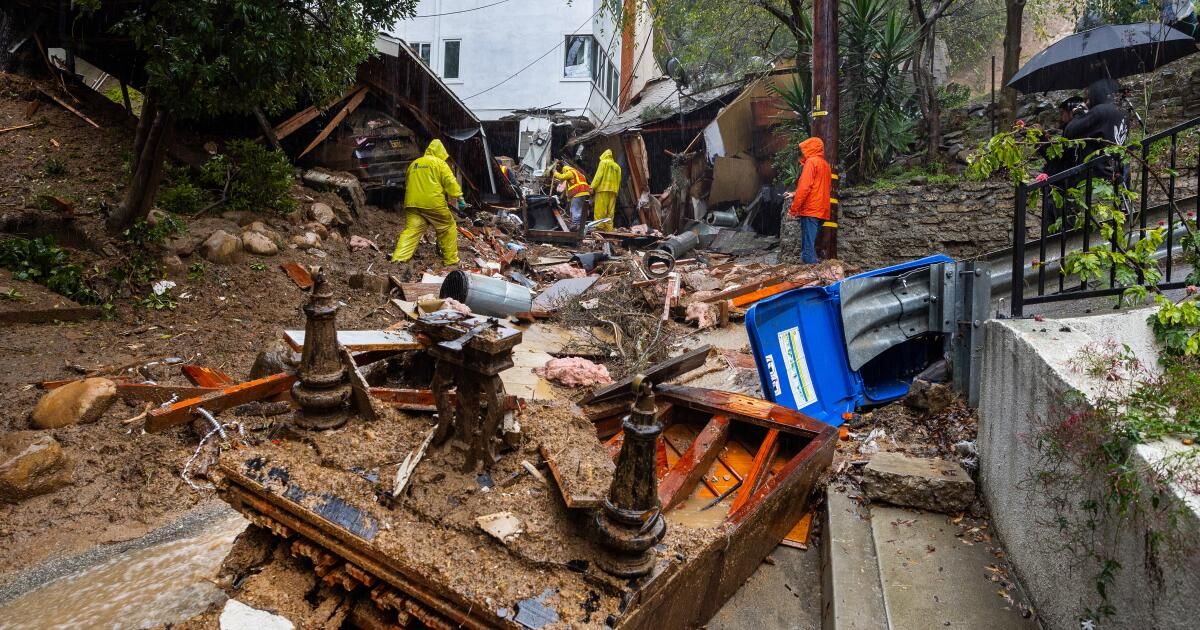
With another day of rain drenching soggy Southern California, multiple warnings and evacuation orders are in effect Tuesday for residents of Los Angeles, Ventura, Orange and San Bernardino counties.
An evacuation order, which has the force of law, is an order to leave the area immediately due to an immediate threat to life. An evacuation warning is an alert about a potential threat to life or property, and leaving the area is voluntary.
Los Angeles County
Authorities issued evacuation orders for the following areas with burn scars from past wildfires that increased the risk of mud and debris flows, urging residents to gather family members, pets and medications and leave immediately.
- Santa Maria Road north of Topanga Canyon Boulevard
- Soledad Canyon Road east of Agua Dulce Canyon Road
Culver City issued an evacuation warning to residents of the Upper Crest neighborhood Monday night. The warning will be in effect until the end of Tuesday and extends to residents of the following streets:
- Cranks Road (Tellefson Road to St James Drive)
- Tellefson Road (Cranks Road to Stubbs Lane)
- Ranch Road (Tellefson Road to Cranks Road)
- Stubbs Lane (in its entirety)
- Camino de Lugo (in its entirety)
- Youngworth Road (Ranch Road to Flaxton Street)
- Flaxton Street (Youngworth Road to Drakewood Ave)
- Drakewood Avenue (Ranch Road to Northgate Street)
- Bernardo Road (Tellefson Road all the way)
The Los Angeles County Department of Public Works issued a mudflow alert for homes affected by the 2020 Ranch 2 Fire. Emergency officials issued an evacuation warning for four homes in the Mountain Cove community, which will be effective until Tuesday morning.
Other areas with burn scars were given evacuation warnings, instructing residents to leave now if they need more time to evacuate or if they have animals that need shelter. The warnings, which will be in effect until at least 6 p.m. Tuesday, include:
- Juniper Hills and Valyermo areas affected by the Bobcat fire
- The Lake Hughes and King Canyon areas affected by the Lake Fire, particularly the 20000 block of Pine Canyon Road, the 18000 block of Ellstree Drive, the 46000 block of Kings Canyon Road, the 18000 block of Newvale Drive, and the 43000 block of Lake Hughes Trail
- All of Topanga Zone 4 in the northeast part of the canyon is not under an evacuation order.
- In the city of Duarte, along Mel Canyon Road between Fish Canyon Road and Brookridge Road.
According to Los Angeles County officials, shelters are available at two locations: ONEgeneration at 18255 Victory Blvd. in Reseda and Marie Kerr Park at 39700 30th St. West in Palmdale. For animal shelters, the county directs people to the Agoura Animal Care Shelter at 29525 Agoura Road in Agoura Hills and the Castaic Animal Care Center at 31044 Charlie Canyon Road in Castaic.
Ventura County
An evacuation warning is in effect for:
- The unincorporated region around Ojai, Matilija Canyon, North Fork and Camino Cielo. According to emergency officials, there is no access to the area due to storm damage.
orange county
The Orange County Sheriff's Department issued evacuation warnings for the following areas:
- Lake Irvine
- Black Star and Baker Cannon
- Silverado Canyon
- Williams Canyon
- Modjeska Canyon
- Live Oak and North Trabuco Canyon
- Blunderbuss, Rose, Holy Jim Canyon
For more information, call 211. Residents in need of shelter are encouraged to make arrangements with family or friends, or call the American Red Cross at (855) 891-7325.
San Bernardino County
Evacuation warnings have been issued for three mountain communities: Seven Oaks, Angelus Oaks, Barton Flats and Forest Falls. The county also warned of possible flooding within and downstream of burn areas in Oak Glen, Yucaipa and Mountain Home Village.
Residents of those communities who need a shelter for their small animals can bring them to the Devore Animal Shelter at 19777 Shelter Way in San Bernardino. For help, call San Bernardino Animal Care at (800) 472-5609.
Road closures
A list of road closures as of Tuesday morning included:
- Near Dodger Stadium, just north of downtown Los Angeles, the connector between the southbound 5 Freeway and the southbound 110 Freeway was closed indefinitely due to multiple mudslides. So was the access ramp from Riverside Drive to the southbound 5.
- Near Lake Los Angeles, 110th Street East from Avenue K to Avenue I due to flooding.
- In south Los Angeles, the westbound 60 Freeway connector to the westbound 10 Freeway was closed indefinitely due to an accident.
- In the Santa Monica Mountains, State Route 27 is closed indefinitely from Topanga Canyon School Road to Robinson Road due to flooding of Topanga Creek. Additionally, landslides closed a portion of Hillside Drive east of Summit Road.
- In Covina, Covina Hills Road from Rancho Del Monico Road to Rancho La Carlota Road was closed due to flooding.
- In Palmdale, East Palmdale Boulevard was closed at 87th Street East.
- In the Roosevelt community of Lancaster, Avenue I was closed from East 60th Street to East 70th Street due to flooding. In the Quartz Hill community, 45th Street West was closed from Avenue K to Avenue K-8 due to pavement failures.
- In Sylmar, the westbound Highway 210 on-ramp was closed indefinitely due to weather conditions.
- In the southeastern Antelope Valley, Mt. Emma Road was closed from Cheseboro Road to 87th Street East due to storm activity.
- In Castaic, Lake Hughes Road was closed from Pine Canyon Road to Dry Gulch and from Lake Hughes Road to Three Points Road due to mudslides.
- In the San Gabriel Mountains, the Angeles Crest Highway was closed in two sections: from Mount Wilson Road to west of the Upper Big Tujunga River, and from the State Route 39 interchange to the Big Pines Highway. Additionally, State Route 39 was closed from Angeles Crest Highway south to two miles north of Crystal Lake Road.
- South of Seal Beach, Pacific Coast Highway was closed indefinitely from Warner Avenue to Seapoint Street due to flood control.
- In downtown Ventura, one of the three southbound lanes of Highway 101 near California Street is closed indefinitely due to flooding.
- In and out of Ojai, State Route 33 is closed indefinitely in both directions from Fairview Road to the Ozema Fire Station due to mudslides. A video from the area showed pieces of mud and rocks spread out on the other side of the road.
- Also in Ojai, McNell Road from Reeves Road to Grand Avenue and Camino Cielo from State Route 33 to the end.
- In North Star Ranch, ramps connecting Highway 15 to Main Street were closed for emergency work.
- North of Silverwood Lake, State Route 173 was closed from State Route 138 to Lake Arrowhead Road for emergency work.
- In South Fontana, the eastbound 10 Freeway exit at Citrus Street was closed due to emergency work.
sandbags
If you need sandbags to protect your home or property, the Los Angeles County Fire Department makes empty sandbags available to residents for free at all of its stations, with free sand to fill them in select locations. To find sandbags and sand near you, visit the county Public Works website or check out this list from the Fire Department.
In Orange County, sand and sandbags are available at certain fire stations, the county yard, and some city public works departments. There is a list with links on the Orange County Fire Authority website.
In Ventura County, two dozen fire stations offer free sandbags to residents, although you'll have to fill them yourself. The Ventura County Fire Department website has a list of participating stations. The Ventura County Department of Public Works also offers a list of retailers that sell sandbags, along with instructions on how to fill and handle them safely.
In San Bernardino County, residents can get free empty sandbags at fire stations across the county, although only some of those stations also offer sand. To find a station near you, check the list on the San Bernardino Fire Protection District website.