A year ago, officials were sounding the alarm about a bone-dry winter that days later would combine with wind gusts of up to 100 mph to spark the worst fires in Los Angeles history.
Now, Southern California just experienced the wettest Christmas in its modern history.
This Christmas Eve and Christmas Day were the wettest on record in many parts of Southern California, according to the National Weather Service office in Oxnard. And more rain is coming. A flood watch is forecast to remain in effect for much of the state until at least Friday afternoon, with rain expected throughout the day. Skies should clear up by the weekend.
This is also one of the wettest starts to the water year, which began on October 1, ranking in the top 10. Until Christmas noon it was already among the 10 wettest in Southern California, the complete opposite of last year.
The rain brought needed moisture to dry vegetation and helped keep the state out of drought conditions, further eliminating the risk of wildfire. It also speaks of a broader cycle.
Last year was notably dry and hot. The summer and fall of 2024 were some of the hottest months on the Southern California coast since at least 1895. California experienced its hottest July ever in 2024.
Around the world, people are seeing more dramatic shifts between dry-to-wet and wet-to-dry weather whiplash. Scientists say that more such episodes “hydroclimatic whiplash”They are anticipated all over the world due to man-made global warming.
A flood watch was expected to be in effect for most of California until at least Friday afternoon.
(National Weather Service)
Between Wednesday and noon Thursday, the Santa Barbara Airport received 4.83 inches of rain, surpassing the Dec. 24-25 record last set in 1955, when 3.22 inches fell. Rain forced the Santa Barbara airport to close twice on Christmas Day: early in the morning and again in the late afternoon. The airfield may be flooded with heavy rain, which will force commercial flights to be suspended; Crews worked overnight into Friday morning to pump water from the field.
Woodland Hills received 4.62 inches of rain, surpassing the record of 3.34 inches set in 1971; Oxnard, 4.26 inches, breaking the record of 2 inches in 1979; Van Nuys, 4.12 inches, surpassing the record of 1.16 inches set in 2019; Burbank, 3.5 inches, breaking the record of 3.1 inches in 1971; Camarillo, 3.36 inches, breaking the record of 2 inches in 1979; and UCLA, 3.05 inches, surpassing the record of 3.02 inches set in 1971.
So far, downtown Los Angeles has recorded 2.59 inches since Christmas Eve, which is the fourth wettest period on record. The record for December 24-25 is 3.82 inches in 1889.
The last day the period between Christmas Eve and Christmas was wetter was in 1971, when 3.24 inches fell over the two-day period.
“There is a good chance that rain totals could increase through midnight tonight and possibly change this classification,” the weather service said Thursday afternoon.
Precipitation totals were much higher in the mountains. During the 48-hour period ending at 9 a.m. Thursday, nearly 12 inches of rain fell on Ortega Hill in Ventura County. And more than 10 inches of rain fell in parts of the San Gabriel Mountains in Los Angeles County.
A final burst of rain was expected to make its way across the Central Coast starting Thursday night and move out of Los Angeles County on Friday, with showers tapering off late tonight. Los Angeles County could see 1 to 1.5 inches of rain on the coast and valleys (perhaps more in certain places) and about 4 inches in the mountains.
“The threat of flooding will be exacerbated … on Friday due to oversaturation of the entire area. Any rainfall that occurs will immediately turn to runoff,” the weather service office in Oxnard said.
Evacuation orders remained in effect for dozens of homes in the Riverwood neighborhood of Sunland. The neighborhood could be at risk due to a partial release of water from the Tujunga Dam by the Los Angeles County Department of Public Works, city officials said, which aims to prevent potential flooding in the surrounding area. “This is a standard process that has been carried out in the past,” officials said.
Evacuation warnings have been issued in recent burn areas in Los Angeles County, and evacuation orders have been issued for specific homes at increased risk of landslides.
Moderate rain was expected in the San Bernardino Mountains through Friday morning, moving eastward, “which at times can be heavy in the mountains,” the San Diego weather service office said.
Rainfall is expected to be about a half-inch per hour, and “of particular concern are the overly saturated portions of the San Bernardino Mountains and adjacent drainage basins extending into the Inland Empire and High Desert regions,” the weather service said. An additional 1 to 3 inches of rain is expected in the San Bernardino Mountains.
2 to 3 inches of snow is possible around 7,000 feet elevation in the San Bernardino Mountains, with 8 to 12 inches near mountain peaks.
Elsewhere in Orange County, San Diego County and parts of the Inland Empire, light rain showers remain possible through Friday night and will eventually taper off Saturday morning, the San Diego office said.
Between 1 and 1.5 inches of additional rain is expected in Orange County and parts of the Inland Empire along the San Bernardino Mountains. Between 0.25 and 0.75 inches of rain are expected along the coast and valleys of San Diego County and the rest of the Inland Empire.
Dryer weather is expected across California early next week. But there is a possibility of a moderate to strong wind event in Santa Ana in Southern California early next week.
It's also possible that precipitation could return to Southern California around New Year's Day, but by the time the storm appears it would be “a much less intense event” than the Christmas Eve atmospheric river storm, the San Diego office said.
The Christmas storms have caused significant damage across California, resulting in at least three storm-related deaths: a motorist who plunged into flood waters in Redding; a woman who was knocked off a rock by a large wave on a Mendocino County beach; and a man hit by a falling tree in San Diego.
Two people were killed in a crash involving three vehicles on the Grapevine section of the 5 Freeway Thursday around 3 p.m. Authorities have not yet said what caused the accident.
Governor Gavin Newsom declared a state of emergency in Los Angeles, San Diego, Orange, Riverside, San Bernardino and Shasta counties, allowing state resources to be mobilized quickly and authorizing Caltrans to seek federal help to repair damaged roads.
Damage was reported across the state, with flooding, mudslides and downed trees also reported in the Central Valley and San Francisco Bay Area. Tornado warnings were briefly issued for the San Gabriel Valley on Wednesday and for parts of San Mateo and Santa Cruz counties on Thursday.

Misty Cheng looks at the flood damage at her home in Wrightwood on Thursday.
(Eric Thayer/Los Angeles Times)
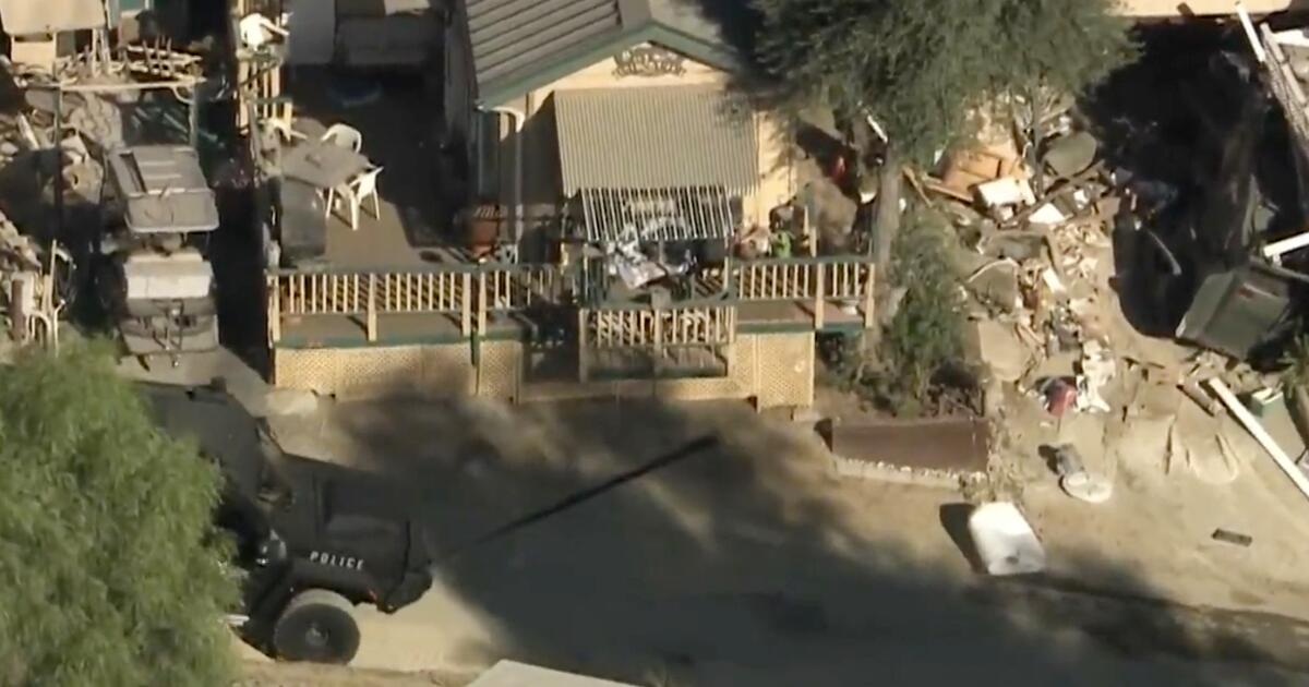
Among the hardest hit areas is Wrightwood, a city of a few thousand people in the San Gabriel Mountains, on the border between Los Angeles and San Bernardino counties. A debris flow on Christmas Eve, a rapid flow of mud and rocks, crashed into homes and left cars buried in rubble.
There was damage to several properties and there were several swift-water rescues, with nearly 10 inches of rain recorded in the area in a 24-hour period, the weather service said.
People in Lytle Creek, another mountain community in the San Gabriel Mountains, were trapped after a bridge connecting parts of the city was covered in water and possibly destroyed.
Evacuation warnings were in place for Wrightwood and Lytle Creek.
A woman was rescued after being seen being swept into San Jose Creek in the San Gabriel Valley, near Fullerton Road off Highway 60, in an area around the City of Industry. She was rescued near Workman Mill Road, near the unincorporated community of North Whittier, near the intersection of Highways 605 and 60.
Major highways had been closed for hours due to the storm's impacts, including Interstate 15 through Cajon Pass and Interstate 5 in Sun Valley.
Los Angeles firefighters deployed crews to several river rescue incidents; one involved the rescue of a man, his dog and his cat who were in a recreational vehicle on an island in the middle of a stream, and were trapped by rising waters. The three were put on a helicopter.
On Friday morning, a woman in her 20s was seen being swept away by fast-moving waters in Tujunga Wash, near Branford Street in Pacoima. She traveled about 10 miles, down the Tujunga Wash through much of the San Fernando Valley and into the Los Angeles River, before being rescued near Universal City, where the waterway crosses Lankershim Boulevard.
The woman was transported to a hospital and treated for minor injuries, including hypothermia, the Los Angeles Fire Department said.
The Los Angeles County Sheriff's Department said it responded to numerous vehicles trapped due to flooding in the Antelope Valley.
Times staff writers Terry Castleman, Noah Goldberg and Amy Hubbard contributed to this report.