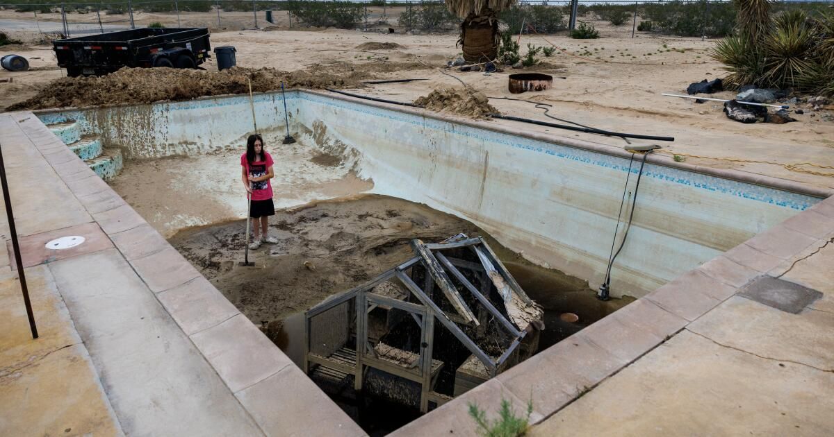
In the height of summer, most Southern Californians would be surprised to see more than a handful of clouds in the sky (unless you count smoke clouds from wildfires). But on July 14 in Twentynine Palms, a rapidly developing thunderstorm dropped about 1.88 inches of rain in a couple of hours — an overwhelming amount by historical standards for a city that typically receives less than 4 inches in an entire year.
Water rushed through streets and roads, sweeping away vehicles and debris, damaging homes and businesses. Then, as residents were still assessing the destruction, nine days later the area was again placed under a flash flood warning as another thunderstorm approached.
So why does the Mojave Desert—obviously an extremely arid place—get all this summer rain while Los Angeles, less than 150 miles away, gets none?
Aggressive and shocking reports on climate change, the environment, health and science.
Late summer is the driest time of year for much of California; on average, Los Angeles International Airport receives no rain at all during the month of August. But travel east across the mountains into San Bernardino County and the pattern changes suddenly: In Twentynine Palms, August is the wettest month. Continue into Arizona and New Mexico and late summer rainfall becomes even more intense: In Santa Fe, nearly half of the year's rain falls between July and September.
This change is the result of a phenomenon called the North American monsoon, which was responsible for the deluge at Twentynine Palms. While less well-known than its South Asian counterpart, the North American monsoon plays a major role in the climate of the Four Corners states, bringing crucial moisture to otherwise bone-dry areas, but also sometimes causing damaging flooding.
All monsoons have the same source of energy: the temperature difference between land and ocean. During the warm months of late summer, the sun can emit up to 1,000 watts per square meter in subtropical areas – in power terms, that’s equivalent to having a heater on every 4 feet. Some of this energy is reflected back into space, but on average more than two-thirds of it is absorbed, either by the land surface or the ocean.
The essential difference between the two is that the ocean is constantly mixing, which distributes heat throughout the top 20 meters of ocean water, something that is impossible on land. As a result, the top few centimeters of soil or rock heat up rapidly over the course of a day, and in turn warm the air above them.

Monsoon flood waters buckled and damaged the roadway at Kelbaker Road and Mojave Road within the Mojave National Preserve in August 2022.
(NPS)
Because warm air is less dense than cold air, the air over land tends to rise, usually in the late afternoon after a full day of baking in the sun. As the air rises from the land, it draws in moist air from the water (in the case of the North American monsoon, that's the Gulf of California) to replace it. When this moist air reaches mountainous terrain like that of northern Mexico and the southwestern United States, it is pushed upward and loses its moisture, often in sudden, intense thunderstorms.
There are many places near the coast that don't get monsoons, like Los Angeles, for example. One important factor is topography: research suggests that one of the main reasons the South Asian monsoon is so strong and consistent is the presence of the Himalayas, which act as a barrier to prevent air from the dry Tibetan Plateau from reaching the Indian subcontinent.
Another important consideration is something called the “subtropical ridge,” which is a series of persistent high pressure systems that all occur about 30 degrees north (and south) of the equator.
The reason the North American monsoon doesn't reach the California coast is the presence of the North Pacific high pressure, which is part of the subtropical ridge normally found northeast of Hawaii. The North Pacific high pressure strengthens and expands during the summer, creating the warm, dry conditions typical of Los Angeles and displacing the monsoon. However, in the winter, the North Pacific high pressure tends to weaken and shift southward, allowing atmospheric rivers to reach the state.
For the Southwest, the North American monsoon can be both a blessing and a curse.
The monsoon brings much-needed rain to the region, but that rainfall often falls in torrential downpours that the dry, hard ground can't absorb. This causes dangerous flash floods that can destroy roads and buildings and potentially cost the lives of those in its path. The rain and cool conditions that the monsoon brings can be helpful in extinguishing wildfires, but lightning from storms is also a major trigger for wildfires in the region.
As with many weather phenomena, climate change is expected to have some effect on monsoon rainfall, but the magnitude and direction of that effect depends on specific local factors.
In some parts of the world, such as South and East Asia, monsoons are expected to intensify due to climate change. Changes in aerosol pollution as China and India (hopefully) transition away from coal-based energy are thought to play a big role.
In the Southern Hemisphere, models suggest a possible small increase in summer monsoon precipitation. Of the major monsoon systems, only the North American monsoon is expected to have substantial decreases in total precipitation, with the most likely outcome being a 1% to 6% reduction in summer precipitation. The reasons for this projected decrease are not fully understood, but increased sea surface temperatures off the coast of Baja California have been suggested as a possible explanation.
If the North American monsoon weakens in the coming decades, it will increase pressure on the dwindling Colorado River, whose watershed encompasses almost all of Arizona and large swaths of Colorado and Utah. And, perhaps more importantly, it will pose a serious threat to ecosystems already fragile because of rising temperatures and outbreaks of the mountain pine weevil.
The future of monsoon systems around the world is neither certain nor easily predictable, but given the potential dangers in both directions – more intense flooding or deeper droughts – it is important that we prepare for both scenarios and act quickly to limit these changes, including by rapidly reducing emissions.
Ned Kleiner is a scientist and catastrophe modeler at Verisk. He holds a PhD in atmospheric sciences from Harvard.
Fact Sheet
Towards a more sustainable California
Receive Boiling Point, our newsletter exploring climate change, energy and the environment, and be part of the conversation – and the solution.
You may occasionally receive promotional content from the Los Angeles Times.