In the dead of winter, Los Angeles is defined less by cold than by light. Crisp, clear mornings give way to afternoons shaped by the low arc of the winter sun, painting the mountains with long shadows and the sky with unlikely colors.
And as that dim light settles in, my whole body changes spirit. Somewhere deep in the limbic system, a synapse fires like a flare, tracing the old circuits of migration and memory: that annual draw to the open deserts of the American Southwest.
I dream of lizards, dark skies, sand dunes and sunsets streaked with mauve pink and smoky violet, the air heavy with the scent of wet creosote and campfire smoke.
A sunrise in the desert.
(Josh Jackson)
But most of all I long for the open road, those forgotten highways where the pavement passes through quaint towns, weather-worn monuments, and millions of acres of public land in the desert. It is a nostalgia shared by chroniclers of the past.
In 1971, Lane magazine published “California Backroads”, a large-format book that included travel notes and sketches of 42 back roads by the late artist Earl Thollander.
In the afterword he writes: “On the back roads of California I rediscovered the joy of driving. It had nothing to do with haste, but with taking the time to perceive, with full awareness, the ever-changing colors, designs and patterns of the land.”
Many of those original roads have vanished, swallowed by high-speed highways or erased by suburban sprawl. But a handful still survive: routes that do not trace a straight line but follow the winding, undulating contours of the terrain. They are living archives of the West.
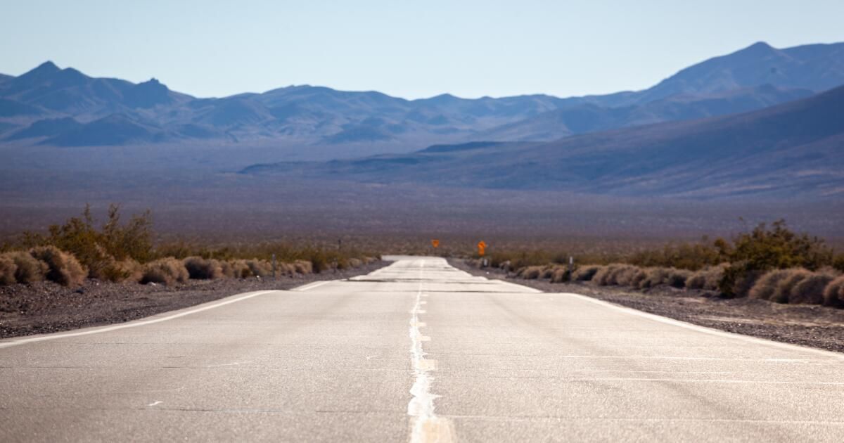
This essay marks the beginning of a series exploring those remaining paths. And we started on Highway 127, a two-lane stretch that runs north from Baker, slowly ascending and descending toward the Nevada border. To the west are the outskirts of Death Valley National Park; to the east, millions of acres of public lands managed by the Bureau of Land Management, areas collectively owned by all of us.

The Baker Country Store.
(Josh Jackson)
I arrived in Baker at dawn in early December, camera in hand and notebook in my pocket. The highway sign was almost indecipherable under layers of stickers and graffiti.
I drove north out of the city, the 41-degree air still holding the chill of the night, and was greeted by shifting light and the empty, open scale of the desert. The full moon fell towards the Avawatz Mountains as the sun made its way over the horizon in the east. The dry lake beds and bare mountains were bathed in glow and shadow, the entire scene bathed in cinnamon and brown sugar, earthy tones that seemed almost edible.

Dumont Dunes, a playground for sand dune enthusiasts, is bordered by the lazy Amargosa River.
(Josh Jackson)
At kilometer 34, the winter light had begun to settle on the landscape. A short spur leads to Dumont Dunes, a popular off-road vehicle area, but I got to witness the miraculous channel that emerges above ground on its 185-mile horseshoe journey from Nevada to Badwater Basin: the tiny but mighty Amargosa River.
Here he pushes and digs through a canyon of mud walls that resemble the color of a wasp's nest. The crows fly above me, cawing defiantly at my presence. The sight of water in the arid desert disturbs your perceptions. It's hard to resist the urge to lie down and take a bath, even in winter. I bend down, grab a handful of cold water, and splash it on my face.

Amargosa Canyon is known for its spectacular rock formations.
(Josh Jackson)
He Bitter Conservation and local tribes have worked for decades to protect this river for its cultural and biodiversity values. As CEO Mason Voehl told me, it is “the soul of these lands. The fate of every community of life on this edge of the Mojave Desert is inextricably linked to the fate of the river.”
Kneeling on the riverbank, I understood exactly what he meant.

The Shoshone Post Office.
(Josh Jackson)

Built in the 1930s, Crowbar Cafe & Saloon is like a time capsule.
(Josh Jackson)
Twenty-two miles further north, Shoshone appears as a small village serving a couple dozen residents. A gas station, post office, general store and the Crowbar Café & Saloon anchor the town.
I met Molly Hansen, the community's unofficial historian and naturalist, in her low-ceilinged office near the center of town. We walked to the edge of town, where spring-fed pools guard the fate of the only Shoshone pupfish population in the world. They were once thought extinct, but were rediscovered in a metal sewer in 1986. Today they dart and shimmer across the warm water: tiny, minnow-like survivors whose breeding males flash a brilliant desert blue.
Hansen pointed to the springs. “We're not just trying to save a species,” he said. “We are trying to restore the entire ecosystem.”
This ecosystem persists in large part thanks to Susan Sorrells, who owns the town and a thousand surrounding acres. As the main defender of the proposal Cuenca Amargosa National MonumentShe is working to protect this entire corridor: the river, the wetlands, and the deep cultural history woven through these desert valleys. Shoshone may be a small dot on a map, but it contains something surprising: the reminder that the desert doesn't have to be a place where things go to die: it can be a place where they begin again.

Eagle Mountain.
(Josh Jackson)
Just after mile 72, Eagle Mountain begins to tease the horizon. At first, only its jagged top pierces the low hills, as if surfacing for air. In the end, the entire massif is exposed: a solitary block of limestone rising 1,800 feet above the Mojave floor. Its isolation is striking, a guardian island out of place.
For the Southern Paiute and Western Shoshone, Eagle Mountain has deep cultural meaning, woven into their creation stories and Salt Songs, understood as a “passage to heaven.” Even with my limited knowledge, the mountain radiated a kind of gravity, as if the desert itself were remembering.

Bitter Opera.
(Josh Jackson)
At mile 83, the Amargosa Hotel and Opera House appears, one of the strangest and most charming places in the Mojave. Its stucco walls and Spanish arches were once part of a Pacific Coast Borax company town, which was later abandoned when the boom ended. In 1967, Marta Becketta professional ballet dancer from New York, accidentally had a flat tire nearby and fell in love. Shortly afterward, he moved into the outpost, purchased the hotel, and spent the rest of his life preserving the landmark and restoring the opera house, where he performed for audiences large and small until 2012. Today, the hotel and theater remain open: faded, fragile, and absolutely magnetic.
The last seven miles of Highway 127 passed quickly and the sun crept toward the western horizon as it crossed into Nevada, eight hours after starting.
Turns out Thollander was right: This experience had nothing to do with rushing. These back roads teach a different rhythm: the wonders of taking the long way, of stopping when something catches your eye, of noticing beauty that doesn't demand attention. In a world increasingly defined by speed and distraction, this slow way of seeing becomes more than nostalgia; It becomes an antidote to the frenetic pace of our modern condition, a necessary pause to see not what has been forgotten, but what endures.
Road Trip Planner: California Highway 127

Illustrated map of California 127.
(Map illustrated by Noah Smith)
The route: Baker to the Nevada state line
Distance: 91 miles (one way)
Driving time: 1.5 hours straight; allow a full day for stops
Best time to go: From the end of October to April. Summer temperatures frequently exceed 110°F
Fuel and essential elements:
- Baker (Mile 0): Latest important services. Fill your tank and stock up on water/supplies here.
- Shoshone (Mile 57): Gas station, general store and post office available.
- Electric vehicle charging: Fast chargers available from Baker; Level 2 chargers available at Shoshone Inn.
Food and drink:
- Los Dos Toritos Restaurant in Baker: Authentic Mexican.
- China Ranch Date Farm (Mile 48): A historic desert oasis along the Amargosa River; famous for date smoothies.
- Crowbar Cafe and Lounge in Shoshone: The local watering hole. Hearty meals and cold beer.
Camping:
- Dumont Dunes: A wind-shaped sand dune complex designed for off-road vehicle recreation. Primitive camping (permit required, purchase on site or online).
- Shoshone Trailer Park: Full hookups, tent sites, and hot spring pool access.
Accommodation:
Walk and explore:
- Amargosa River Crossing (Mile 34): Get out safely to see the rare sight of flowing water in the Mojave.
- China Ranch Trails (Mile 48): Creek Trail Iyes a short, easy walk through riverside willows; Slot Canyon is a moderate 2 mile hike into spectacular mud hill geology.
- Shoshone Wetlands (Mile 57): Short walking trails to see Shoshone pupfish habitat.
- Bitter Opera (Mile 83): Tours of Marta Becket's Painted Theater typically run daily (see online schedule); Walk the grounds to see the historic ruins of Borax City.
Safety Notes:
- Water: Carry at least one gallon per person per day.
- Connectivity: Cell service is spotty or nonexistent between Baker and Shoshone. Download offline maps before you exit I-15.
- Fauna: Keep an eye out for wild donkeys and coyotes along the way, especially at dawn and dusk.