In early spring, the California mountain town of Julian is suspended between seasons. At over 4,000 feet in the Cuyamaca Mountains, it rests among coastal oak forests and Coulter pine forests. Snow sometimes covers the surrounding slopes and in the afternoon it melts into the moist earth when the manzanita and mountain lilac begin to bloom. Along Main Street, the mixed aromas of wood smoke and apple pie waft from storefronts.
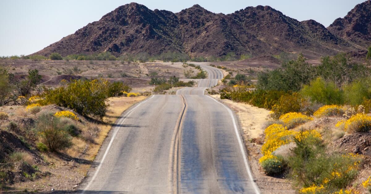
It is here that my journey along State Route 78 begins, following its long eastward descent from the mountain forest to the desolate badlands of the Anza-Borrego Desert State Park, then skirting the southern edge of the Salton Sea, crossing the Algodones Dunes, and continuing toward the Colorado River, a 140-mile corridor that encompasses one of the most spectacular ecological transitions through public lands in the American Southwest.
This road trip continues a series exploring California's overlooked, scenic highways, inspired in part by artist Earl Thollander's “Back Roads of California,” whose sketches and travel notes celebrated a slower way of seeing. After traveling Highway 127 along the edge of Death Valley, the trip now heads south.
Julian Cafe and Bakery, the beginning of the trip along Route 78.
(Josh Jackson)
Within minutes of leaving town, the pavement twists downward through hairpin curves and steep inclines as the mountain air begins to warm, the vegetation giving way to chaparral and sparse juniper, then to the stark silhouettes of ocotillo and Mojave yucca. By the time it reaches the Pacific Crest Trail junction 12 miles east of Julian, travelers have already descended nearly 2,000 feet.
Here, the highway passes quietly towards Anza-Borrego, homeland of the Kumeyaay, Cahuilla and Cupeño peoples. At nearly 650,000 acres (slightly smaller than Yosemite), the park unfolds as a vast mosaic of mountains, badlands, and open desert valleys that extend far beyond the reach of pavement.

Wildflowers along the route.
(Josh Jackson)
Bri Fordem, executive director of the Anza-Borrego FoundationHe said the landscape slowly reveals itself to those who visit for the first time. “I think a lot of people drive by and say, 'Oh yeah, there's a desert there,'” he said. “But when you stop, go a little slower and look closer, a whole world opens up.”
That invitation begins at mile marker 18, where the Yaqui Pass Road turnoff leads northeast toward the desert basin and the gateway community of Borrego Springs. The 2.8-mile Borrego Palm Canyon Trail offers one of the park's most accessible routes into the desert interior. Cholla gardens and brittle shrubs rise from pale alluvial slopes, and a seasonal stream leads to one of California's few oases of native palm trees.
In wet winters, the valleys beyond the city awaken in color as sand verbena, desert sunflower, evening primrose and pincushion gather in brief, luminous blooms on the desert floor. The Anza-Borrego Foundation track these seasonal displays and offers guidance on how to witness them responsibly.
The short detour returns to Highway 78 along Borrego Springs Road, where the pavement drops sharply across the Texas Dip near mile marker 27, a stark, cinematic wash where scenes from the final sequence of “One Battle After Another” were filmed. Wandering along the stream, the mind goes not to the film but to the flash floods that move through this channel after heavy rains, sudden torrents that cut and reshape the valley floor in a matter of hours.

Ocotillo plants rise from the desert floor at Anza-Borrego Desert State Park.
(Josh Jackson)
The sun hangs in the middle of the sky as I drive toward one of the most rapidly changing coastlines in California. From almost any vantage point, the Salton Sea appears lifeless: a gray expanse rimmed with salt and windblown dust. But at its southern end, that impression begins to change. The watershed is concentrated in shallow wetlands where movement returns to the landscape.
Sixty miles from Julian, I turn onto Bannister Road and head north on a gravel road for three miles toward the basin, reaching a parking lot 164 feet below sea level. The lot is located within Unit 1 of the Sonny Bono Salton Sea National Wildlife Refuge. A short walk along an irrigation canal leads to a weathered viewing platform that rises two stories above a mosaic of saturated plains where saltgrass, iodine bush and cattails take root. Here, the Pacific Flyway it is compressed into a living mosaic of wings, water and land. Each spring, hundreds of thousands of birds gather here to feed and rest before soaring north again, following migratory routes much older than the farms and roads that now define the valley.

Wetlands near the Salton Sea provide vital habitat for birds.
(Josh Jackson)
The place overwhelms the senses: a wash of emerald against the open sky, thousands of snow geese honking in chorus, orange-crowned warblers and Abert's towhees singing in the trees, and the lingering smell of salt in the air.
I find three birders standing silently on the platform, scanning the horizon through binoculars and counting the 73 species of birds they had counted over the past two days: burrowing owls, American avocets, sandhill cranes and black-necked stilts, among them. For 30 minutes we watch a northern harrier hunting, shelling blue-winged and cinnamon-winged teal, though it always ends up empty-handed. Between explorations of the horizon, we come together “Listers”, the 2025 documentary that turns obsessive birdwatching into a comedy and a story of devotion.

A burrowing owl is found at the Sonny Bono Salton Sea National Wildlife Refuge.
(Josh Jackson)
Leaving the shelter, the vibrant color palette and humidity give way to muted browns and the returning austerity of the desert air. At mile 97, the road climbs to the Hugh T. Osborne Overlook, where the landscape changes once again, opening up to a vast ocean of sand.
The Algodones Dunes stretch toward the horizon in pale, wind-sculpted ridges, a narrow ribbon of shifting terrain stretching south toward Mexico. The highway passes directly through its center.
From the viewpoint, the road is read as a line that divides two expressions of the same dune system. To the south is the Bureau of Land Management imperial sand duneswhere buggies and motorcycles trace arcs over bare slopes. North of the sidewalk, the Northern Algodones Dune Desert It has a calmer terrain, where sunflower, ephedra and mesquite honey anchor the sand in a subtle challenge to the wind.

A person walks through the Algodones Dunes.
(Josh Jackson)
Here the road becomes a border between different ways of traveling (and loving) the same landscape: speed and stillness, noise and silence, crowds and loneliness.
In the late afternoon, the last few miles take me east toward the Colorado River, where it meanders through willows and cottonwoods. The light softened toward dusk, an evening echo of the same violet sky that hung over Julian at the beginning of the day. After 140 miles, my road trip had come to an end. However, as I set up my tent that night, the movement of the landscapes remained in my mind.
The Colorado continued its long course south. Snow geese rose north from the refuge's marshes. The wind reshaped the dunes, erasing the traces of the day. The wildflowers that had briefly illuminated the desert floor would soon fade as the heat gained strength. The path ended, but the living systems it passed through moved steadily forward, already heading towards the next station.
Road Trip Planner: State Route 78
The route: Julián to Palo Verde.
Distance: 140 miles (one way).
Driving time: 3 hours straight; Allow a full day for stops.
Best time to go: October to April. Summer temperatures frequently exceed 110 degrees.
Fuel and essential elements:
- Julián (Mile 0): Gas station, Julian Market and Deli, many restaurants.
- Borrego Springs (Mile 18): Gas station, grocery stores, coffee shops.
- Brawley (Mile 74): Gas station, restaurants.
Eat and drink:
Camping:
Accommodation:
Walk and explore:
Safety Notes:
- Water: Carry at least 1 gallon per person per day.
- Connectivity: Cell service is reliable along the route.
- Fauna: Watch for bighorn sheep and coyotes along the way, especially at dawn and dusk.

Wildflowers along Highway 78.
(Josh Jackson)